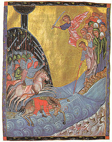
Crossing the Red Sea
[2] Moses holds out his staff and God parts the waters of the Yam Suph, which is traditionally presumed to be the Red Sea, although other interpretations have arisen.
Ramesses is generally identified with modern Qantir, the site of the 19th dynasty capital Pi-Ramesses, and Succoth with Tell el-Maskhuta in Wadi Tumilat, the biblical Land of Goshen.
The Egyptians pursued them, but at daybreak God clogged their chariot-wheels and threw them into a panic, and with the return of the water, the pharaoh and his entire army are destroyed.
[5] The incident of the Egyptian tyrant Pharaoh chasing down Moses and the Israelites, followed by the drowning in the sea, is mentioned in several places in the Quran.
However, after the Children of Israel had safely crossed to the other side, the waters suddenly began to close in on Pharaoh and his soldiers and they all drowned.
Surely many people are heedless of Our Signs.The theme of Moses crossing the Red Sea was taken up by the panegyrists of Constantine the Great and applied to the battle of the Milvian Bridge (312).
[citation needed] The theme enjoyed a vogue during the fourth century on carved sarcophagi: at least twenty-nine have survived in full or in fragments.
[12] Eusebius of Caesarea cast Maxentius, drowned in the Tiber, in the role of Pharaoh, both in his Ecclesiastical History and in his eulogistic Life of Constantine.
The most popular interpretation holds that the crossing was of the modern Red Sea, potentially at its widest and deepest place.
[24] Most maps depicted these bodies of water with grossly distorted proportions, omitting gulfs and other features altogether, and Greco-Roman writers used only imprecise allusions.
Hoffmeier equates yam suf with the Egyptian term pa-tjufy (also written p3 twfy) from the Ramesside period, which refers to lakes in the eastern Nile delta.
[32] He also describes references to p3 twfy in the context of the Island of Amun, thought to be modern Tell el-Balamun,[33] the most northerly city of Pharaonic Egypt, located about 29 km southwest of Damietta.
[36] Naum Volzinger and Alexei Androsov believe that a reef running from Egypt to the north side of the Red Sea used to be much closer to the surface at approximately 1500 BC and therefore a crossing in the northern part of the Gulf of Suez is plausible.
[37][38] Alan Gardiner proposes the northeast Nile Delta, in the "marshy and watery region that now comprises the southern extremity of [Lake] Menzaleh".
Carl Drews propose that the Israelites crossed a 3-4 km land bridge along the Lake of Tanis, in the Nile delta.
[36] Ron Wyatt, Lennart Mueller, Bob Cornuke, and Glen Fritz propose Nuweiba Beach in the Gulf of Aqaba.
The pillar of fire and cloud described in Exodus could easily be a volcanic eruption column, smoky by day and fiery by night.
The occurrence of a fata morgana is dependent on a precise combination of winds and temperatures, but could have lasted for the duration of the Israelites’ journey through a body of water.