Croydon, Cambridgeshire
It is 10 miles (16 km) south-west of Cambridge and immediately west of the A1198 road (the Roman Ermine Street).
The village's name was spelled Crauudene in the 1086 Domesday Book – it is derived from the Old English crawe and denu, meaning 'valley of the crows'.
Open fields surrounding Croydon village were enclosed for pasture around 1640, but from the late 18th century arable farming recommenced.
It has been designated a Scheduled Ancient Monument and is west of Croydon village; a footpath known as the 'Clopton Way' runs past it.
It was mentioned in the 1086 Domesday Book, when 18 peasants were in residence and a Friday market was granted in 1292 to Robert Hoo, lord of Clopton.
[5] The village stood on a prominent ridge and was terraced into the hillside – archaeological excavations have revealed the former locations of a central church, two sites with moats and a probable mill.
[9] It is in the parliamentary constituency of South Cambridgeshire, represented at the House of Commons by Anthony Browne since 2019.
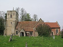
It stands on a slope above the village street and has had problems with subsidence; it is constructed of brick and field stones in the Perpendicular style.
[4] In 1561 it was described as ampla et ornata and said to be in decay; Sir John Cage made efforts to improve it in the 1620s and Sir George Downing, 1st Baronet, rebuilt the chancel in brick and established a family vault, where he was subsequently buried.