Cumberland Gap
At an elevation of 1,631 feet (497 m) above sea level, it is famous in American colonial history for its role as a key passageway through the lower central Appalachians.
Long used by Native American nations, the Cumberland Gap was brought to the attention of settlers in 1750 by Thomas Walker, a Virginia physician and explorer.
The path was used by a team of frontiersmen led by Daniel Boone, making it accessible to pioneers who used it to journey into the western frontiers of Kentucky and Tennessee.
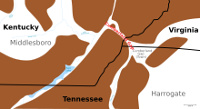
[2] It lies within Cumberland Gap National Historical Park and is located on the border of present-day Kentucky and Virginia, approximately 0.25 miles (0.40 km) northeast of the tri-state marker with Tennessee.
The gap was formed by the development of three major structural features: the Pine Mountain Thrust Sheet, the Middlesboro Syncline, and the Rocky Face Fault.
Lateral compressive forces of sedimentary rocks from deep layers of the Earth's crust pushing upward 320 to 200 million years ago created the thrust sheet.
Less than 300 million years ago a meteorite, "approximately the size of a football field", struck the earth, creating the Middlesboro Crater.
[2] One of three astroblemes in the state, it is a 3.7 mi (6.0 km) diameter meteorite impact crater[5] with the city of Middlesboro, Kentucky built entirely inside it.
In 1769 Joseph Martin built a fort nearby at present-day Rose Hill, Virginia, on behalf of Walker's land claimants.
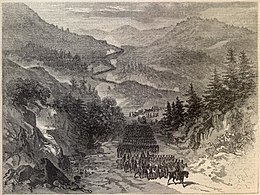
In September of that year, Confederate States Army forces under Edmund Kirby Smith occupied the gap during General Braxton Bragg's Kentucky Invasion.
Visitors to the park can expect to see gray squirrels, white-tailed deer, cottontail rabbits, songbirds, hawks, snakes, turtles, and perhaps black bear or bobcat.