Wilderness Road
The Wilderness Road was one of two principal routes used by colonial and early national era settlers to reach Kentucky from the East.
In 1775, Daniel Boone blazed a trail for the Transylvania Company from Fort Chiswell in Virginia through the Cumberland Gap.
[1] In 1750, Dr. Thomas Walker, an investor in the Loyal Land Company, with five companions, made a famous exploration through the Cumberland Gap and into eastern Kentucky.
The men hoped to purchase land from the Cherokees on the Kentucky side of the Appalachian Mountains and establish a British proprietary colony.
While late 19th and 20th century technologies would later bridge the mountain chain in other places, these all required significant civil engineering works to make a road bed past the barrier range geologist classify as the ridge-and-valley Appalachians.
Starting on March 10, 1775, Boone, along with 35 axmen, cut a trail from Long Island in Kingsport, Tennessee through the forests and mountains to Kentucky.
On March 24, 1775, Boone and his party were only 15 miles (24 km) from their final destination of the Kentucky River when they camped for the night.
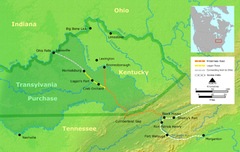
The route of the Wilderness Road made a long loop from Virginia southward to Tennessee and then northward to Kentucky, a distance of 200 miles (320 km).
The trail went through the Crab Orchard approximately 10 miles where a Blockhouse was built to protect settlers in the area and named Logan's Fort.
From there the trail went to the area that became Danville (1783) originally named Crow's Station in 1774, what would become Springfield (1793),[14] Harrodsburg referred to as Harrod's Town or Oldtown and founded by James Harrod on June 16, 1774, abandoned and resettled in 1775, Bardstown (settled in 1780), Shepherdsville (founded as Bullitt's Lick in 1773), and the Falls of the Ohio.
The map shows the trail leaving Louisville through Sullivan's Old Station, Kuvkendahl's Mill, the Fishpools to Bullitt's Lick, then through Bardstown to Danville.
McDowell claims that originally the trail went through Harrodsburg not Danville, and Sullivan's Old Station and Kuykendahl's Mill were not on the main road but high water alternate paths.
Further claims were made that the Wilderness Trail was improved after General George Rogers Clark landed at the Falls of the Ohio which would facilitate the movement of troops and supplies as well as settlers.
[15] In 1784 Filson, also an historian, wrote The Discovery, Settlement and present State of Kentucke and an Essay towards the Topography, and Natural History of that important Country.
[17] Although the Transylvania Company had purchased the region from the Cherokee, and the Iroquois had ceded it at the Treaty of Fort Stanwix, other tribes, such as the Shawnee, still claimed it and lived there.
[18] Defensive log blockhouses built alongside the road had portholes in the walls for firing at Native American attackers.
The tribes were resentful of the settlers taking their ancestral hunting lands, and the French and Indian War had further stirred up their passions against the white man.
At night, the pioneers could hear the hoots and screeches of owls, the howls of wolves, and the cries of panthers and wild cats.
[20] Judge Richard Henderson had made a treaty with the Cherokee at Sycamore Shoals in 1775, purchasing over 20,000,000 acres (8,100,000 ha) of land between the Cumberland and Kentucky Rivers.
On March 28, 1775, he left Long Island (Kingsport, Tennessee) with about 30 horsemen on the grueling trip down the Wilderness Road to Kentucky.
[21] After 1770, a surge of over 400,000 Scots-Irish immigrants arrived in the colonies to escape the poor harvest, high rents and religious intolerance of Ulster.
[23] Often the Chickamauga, under the leadership of Dragging Canoe, would hide in ambush for weeks between Cumberland Gap and Crab Orchard, a distance of 100 miles (160 km).
[25] Chestnut was the most popular wood since its logs could be used to build cabins and rail fences to protect crops from wild animals.
[26] The Wilderness Road served as a great path of commerce for the early settlers in Kentucky, as well as for wagon-loads of slaves being transported through Tennessee to plantations in Mississippi and Louisiana.
Horses, cattle, sheep and hogs herded in the other direction found waiting markets in the Carolinas, Maryland and Virginia.
Frontier settlers considered the postal riders heroes and waited eagerly for their arrival for news from settlements along the trails as well as getting their mail and newspapers.
The Panic of 1837, geology and new railroad technology doomed the James River Canal, once envisioned as augmenting this commercial route.
An early battle (Camp Wildcat), stymied the first Confederate attempt to seize control of neutral Kentucky.
The old road from the town of Cumberland Gap, Tennessee to Middlesboro, Kentucky through the mountain pass was paved and completed on October 3, 1908.
[33] Additionally, a reconstructed fort at Martin's Station in Virginia on the Wilderness Road can be visited about 5 miles (8 km) east of the Cumberland Gap.