2014–15 South Pacific cyclone season
[3] In addition to contributing towards the Island Climate Update outlook, RSMC Nadi and the BoM issued their own seasonal forecasts for the South Pacific region.
[2] Because of its proximity to the warm pool and genesis area, the FMS noted that Tokelau had a low to moderate risk of being affected by a tropical cyclone.
[2] RSMC Nadi also predicted that there was an increased risk of severe tropical cyclones, affecting the region this year when compared to the previous season.
[6] The chances of Fiji, New Caledonia, the Northern Cook Islands and French Polynesia being affected by a severe tropical cyclone were moderate while Kiribati, Tokelau and Wallis and Futuna had a low risk.
[4] During November 21, RSMC Nadi reported that a tropical disturbance had developed about 375 km (235 mi) to the north-west of Mata-Utu, on the French territory of Wallis and Futuna.
[7] Over the next couple of days atmospheric convection surrounding the system gradually became better organised as it moved south-westwards before it was classified as a tropical depression during November 23.
[citation needed] Tropical Disturbance 05F was first noted on December 23, while it was located about 75 km (45 mi) to the north of Mata-Utu in the island nation of Wallis and Futuna.
[citation needed] During January 29, RSMC Nadi reported that Tropical Depression 09F had moved into the basin, from the Australian region to the northwest of New Caledonia.
[15] The system was moving towards the east-northeast and lay within an area of low vertical wind shear underneath an upper-level ridge of high pressure.
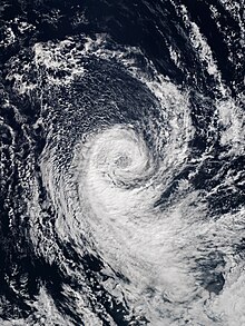
Located in an area of favourable conditions, Pam gradually intensified into a powerful Category 5 severe tropical cyclone by March 12.
[19] Several hours later, the cyclone began to curve towards the south-southeast, allowing Pam to pass just east of Efate,[20] becoming the single worst natural disaster in the history of Vanuatu.
[21] The cyclone crippled Vanuatu's infrastructure: an estimated 90 percent of the nation's buildings were impacted by the storm's effects, telecommunications were paralyzed, and water shortages took place.
[24] Later on March 15, both agencies discontinued issuing advisories as Pam entered a phase of extratropical transition while affecting northeastern New Zealand.
[citation needed] On March 19, RSMC Nadi had reported that Tropical Disturbance 12F had developed about 375 km (235 mi) to the southwest of Apia on the Samoan island of Upolu.
Early on March 22, RSMC Nadi reported that the system had developed into a category 1 tropical cyclone and named it Reuben, while it was located about 220 km (135 mi) to the south of Nukuʻalofa, Tonga.
[citation needed] Between March 20–22, Reuben's precursor tropical depression produced heavy rain and strong winds over Fiji's Lau Islands.
[29][30] The system was located under an upper-level ridge of high pressure and in a region favouring further development, including low vertical wind shear and sea surface temperatures of above 30 °C (86 °F).
[32][33] The system continued to intensify during that day, before both the JTWC and the FMS reported that Solo had peaked with winds of 100 km/h (60 mph) during April 11, which made it a category 2 tropical cyclone on the Australian scale.
[30] As an indirect effect of Solo significant damage was recorded in New Caledonia, with road impassable in places and the drinking water deteriorated in the municipality of Pouébo.
[37][38] Over the next couple of days the system moved westwards into the Australian region, where it developed into a Category 1 tropical cyclone and was named Raquel by the BoM during June 30.
[41] The system subsequently moved south-westwards and out of the basin during July 4, as it impacted the Solomon Islands, with high wind gusts and heavy rain.
[37] Tropical Disturbance 02F developed during December 16, about 360 km (225 mi) northeast of Niue; however, the system was last noted during the next day, as it was suspected to have become an extratropical cyclone.
[51][52] After the season had ended, researchers identified that a possible subtropical or tropical cyclone, had existed to the northeast of Easter Island between April 29 – May 4 and unofficially named it Katie.