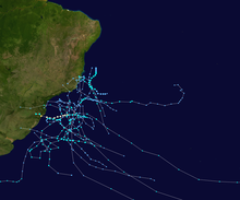
South Atlantic tropical cyclone
[4] Although they are rare, during April 1991 the United States' National Hurricane Center (NHC) reported that a tropical cyclone had developed over the Eastern South Atlantic.
[9][10] In 2011, the Brazilian Navy Hydrographic Center started to assign names to tropical and subtropical cyclones that develop within its area of responsibility, to the west of 20°W, when they have sustained wind speeds of at least 65 km/h (40 mph).
[20] Guided by a trough and a weak ridge to its north, the system moved slowly southeastward over an area of warm waters,[21][22] intensifying into Subtropical Cyclone Arani on 15 March,[23] as named by the Brazilian Navy Hydrographic Center,[24] and achieving its lowest pressure.
[25] Before it developed into a subtropical cyclone, Arani produced torrential rains over portions of southeastern Brazil, resulting in flash flooding and landslides.
[37][38] On 12 March, the Brazilian Hydrographic Center downgraded Cari to a subtropical depression as it achieved its lowest pressure,[39][38] while the CPTEC stated that the storm had become a "Hybrid cyclone"[40] as it moved away from the continental coastline.
[41] Cari brought heavy rainfall, flooding and landslides to eastern cities of Santa Catarina and Rio Grande do Sul states as it interacted with a South Atlantic Convergence Zone.
[42] On 15 November 2016, instability areas associated with a trough axis over Rio de Janeiro's coastline led to the formation of a subtropical depression southwest of it.
[47] Later, it intensified quickly and then transitioned into a subtropical storm shortly before 22:00 BRST (00:00 UTC on 5 December), with the name Eçaí assigned by the Hydrographic Center of the Brazilian Navy.
[49] According to the Brazilian Navy Hydrographic Center, on 8 December 2017 a South Atlantic Convergence Zone aligned with a through axis led to the formation of several instability areas.
[57] Afterward, a cold front would approach the storm, which helped intensify the wind shear impacting Iba, leading to its weakening and extratropical transition.
[61] According to the Brazilian Navy Hydrographic Center, on 19 May 2019 several instability areas formed from a through axis off the coast of Espírito Santo, which later coalesced into a subtropical depression.
[62] On 21 January 2020, the Brazilian Navy Hydrographic Center began monitoring an area of persisting thunderstorms near São Paulo for potential subtropical cyclone development.
[67] According to the Hydrographic Center of the Brazilian Navy, on 24 October 2020, a trough axis persisted off the coast of the border between Espírito Santo and Bahia, which led to the formation of a subtropical depression on the next day.
[68][70] As it moved away from a South Atlantic Convergence Zone on 27 October, Mani gradually lost its subtropical characteristics, until it weakened to a low pressure area.
[74][79] Later that day, Oquira transitioned into an extratropical low, and the Hydrographic Center issued their final advisory on the storm as it was absorbed by a frontal system.
[85][86] For the next few days, the storm slowly meandered southeastward and then southwestward alongside a trough axis to its east,[85] until it lost its subtropical characteristics over high seas on 17 February, becoming a remnant low.
[85][87] The Brazilian Navy noted in its post-season analysis that on late 14 February the system could have intensified into a subtropical storm, since the radiometer built into the AMSR-2 satellite found winds of 35 knots, but it wasn't upgraded because no other measurement confirmed such findings.
[89] Potira moved slowly northeastwards for a couple of days over unusually warmer waters, favorable upper-level tropospheric winds and strong low-level convergence, which led to its intensification and persistence of its peak intensity until 23 April.
[90] As it completed a clockwise loop, Potira weakened into a subtropical depression, with the Brazilian Navy downgrading it to a low-pressure area on late 24 January.
[97] By 23:30 UTC on 28 June, the Satellite Products and Services Division of the NESDIS declared the system to have become a tropical storm, based on a Dvorak rating of 3.5,[98] assigning an invest tag to it.
[95] Although being affected by strong wind shear to its north due to a subtropical jet caused by the presence of a frontal system nearby, it further intensified and achieved a minimum pressure 986 millibars (29.1 inHg), while tracking northeastwards towards the Brazilian area of authority.
[101] Raoni began to weaken by 30 June, as the subtropical jet broke the barotropic flow over it, and NESDIS dropped the tag as it lost its convective bands.
[105] On 9 December 2021, instability areas remained off the coast of Espírito Santo and Rio de Janeiro after the passage of a frontal system and a South Atlantic Convergence Zone.
[120] On 16 February 2024, the Brazilian Navy designated the system, which at the time was east southeast of Rio de Janeiro, Brazil, as a subtropical depression.
[129] The closeness to the Brazilian shore caused wind gusts over the southeastern Rio Grande do Sul, leading to power losses and structural damages on nearby cities.
[7] On 22 February 2006, a baroclinic cyclone intensified quickly and was estimated to have peaked with 1-minute sustained wind speeds of 105 km/h (65 mph), after radar data showed that the system had developed an eye and banding.
On 28 January 2009, a cold-core mid to upper-level trough in phase with a low-level warm-core low formed a system and moved eastward into the South Atlantic.
[136] On 16 November 2010, a cold-core mid to upper-level trough in phase with a low-level warm-core low developed a low-pressure system over Brazil, and moved southeastward into the South Atlantic, where it slightly deepened.
[147][148] On 5 January 2016, the Hydrographic Center of the Brazilian Navy issued warnings on a subtropical depression that formed east of Vitória, Espírito Santo.
[150][152] On 3 January 2021, according to the Météo-France, the remnants of Tropical Storm Chalane from the South-West Indian Ocean crossed southern Africa and briefly emerged into the eastern South Atlantic before dissipating.