Cyclone Xaver
[8] Over the next few days Xaver moved over Southern Norway and Sweden intensifying further, reaching its lowest pressure over the Baltic Sea.
[8] The low pressure system formed on 4 December off the west coast of Iceland and was expected to deepen explosively overnight.
The UK Met Office issued an amber warning over Scotland and northern parts of England, that wind gusts may reach 145 km/h (90 mph).
[10] The Dutch provinces of Friesland, Groningen and North Holland were placed on Red Alert, including the Waddenzee and freshwater IJsselmeer to its south.
[12] In Sweden, the local meteorological institute gave a level 2 warning for central parts of the country due to heavy snowfall and formation of snow drifts.
[14] Meteorologists there likened the early storm readings to those of the North Sea flood of 1962 in which 340 people lost their lives in Hamburg.
[18] In Leeds roads around Bridgewater Place, a tower, were closed to keep to a Coroner's ruling to do so when wind gusts reach 45 mph (72 km/h), after the death of a man by a truck blown over by a vortex in 2011.
[23][25] In Scotland, at 8 a.m. on 5 December 2013 Glasgow Central station was evacuated after the glass roof was broken by flying debris.
ScotRail later cancelled all services in Scotland due to debris including "trampolines, hay bales and trees" falling on the train lines.
In downtown Stavanger, Norway, on the evening of 5 December road traffic and pedestrians were forbidden due to the risk of falling tiles and masonry.
The Isle of Man Steam Packet Company cancelled ferries to and from Douglas due to winds forecast to reach Force 9.
[37] Stavanger's major helicopter hub was closed and all the crafts grounded, pausing in service for North Sea oil platforms.
Homes losing power (including brief blackouts/brownouts) totalled: Xaver brought a significant storm surge to Northern Europe.
North Sea storm surges of similar scale average 1.5 per decade: 15 are listed to have occurred between 1883 and 1979.
The Tees overtopped its estuary into the village of Port Clarance (north) causing a mass-blackout opposite, in Middlesbrough.
It breached a sea wall on Greatham Creek alongside Billingham docks, later repaired using RAF Chinook helicopters.
Humberside Police declared a state of emergency as it reached a record height of 5.8 m (19 ft) against Hull's shore.
Humberside Police released aerial footage from further up the Humber showing great flooding across North Lincolnshire and the East Riding, along the Trent and Ouse.
[71] Boston, Lincolnshire had several defence walls overtopped or breached as the surge rose to levels above those seen in 1953; 800 homes across 55 streets in the town were flooded.
[74] Lowestoft, Suffolk's main harbour, railway station and a southern commercial zone flooded.
[78] In Belgium, Bredene municipality evacuated 2,083 residents in the district between Sas Slijkens and Spuikom along the Bruges-Ostend canal.
In 1953, the water rose to 4.55 m (14.9 ft) on the night of 1 February, and dykes broke in at least 90 places resulting in the worst natural disaster in the Netherlands since the 1900s.
The Eastern Scheldt storm surge barrier closed all its 62 locks on Thursday night and several areas around Rotterdam experienced some flooding.
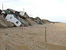
Holiday homes in Nørlev Strand were left undermined as the storm eroded sand dunes, along the Jutland coast.
[38] The BBC addressed criticism after it suspended the regular evening news to cover the death of Nelson Mandela, while communities along the coast were still preparing for flooding.
[92] Under the Flood and Water Management Act 2010, local authorities normally investigate flooding in their boundaries, however Alun Davies the Welsh Assembly Minister for Natural Resources and Food, instructed Natural Resources Wales to co-ordinate the inquiry in Wales as one comprehensive report.
[47] Member of Parliament for Waveney, Peter Aldous initiated a debate in the House of Commons of the United Kingdom as to what went well and what can be improved on a national level as to future flood defences, preparations and so on.
[97] The chief executive of the UK's Environment Agency said in January 2014 that the storm surge may change the coastline of the UK permanently, as the Agency weighs up whether to abandon some land losses permanently; 373 acres (151 ha) in East Anglia were still underwater in January and some defences and freshwater habitats may not be reinstated along the Norfolk-Suffolk coast.
The agency secured £1.5 million to complete the works after the highest surge ever recorded in the estuary brought destruction to defences along the south bank from Whitton to East Halton.
[103] Much of Europe felt the effects of these Atlantic storms: flooding in France, large snowfalls in Austria and Slovenia and damaging waves in Portugal and Spain.