Tsunami
Earthquakes, volcanic eruptions and underwater explosions (including detonations, landslides, glacier calvings, meteorite impacts and other disturbances) above or below water all have the potential to generate a tsunami.
[8] For this reason, it is often referred to as a tidal wave,[9] although this usage is not favoured by the scientific community because it might give the false impression of a causal relationship between tides and tsunamis.
Although the impact of tsunamis is limited to coastal areas, their destructive power can be enormous, and they can affect entire ocean basins.
The term has become commonly accepted in English, although its literal Japanese meaning is not necessarily descriptive of the waves, which do not occur only in harbours.
In recent years, the term "tidal wave" has fallen out of favour, especially in the scientific community, because the causes of tsunamis have nothing to do with those of tides, which are produced by the gravitational pull of the moon and sun rather than the displacement of water.
The Storegga Slide in the Norwegian Sea and some examples of tsunamis affecting the British Isles refer to landslide and meteotsunamis, predominantly and less to earthquake-induced waves.
[12][13] The oldest human record of a tsunami dates back to 479 BC, in the Greek colony of Potidaea, thought to be triggered by an earthquake.
[29] This displacement of water is usually caused by earthquakes,[30][31][32] but can also be attributed to landslides, volcanic eruptions, glacier calvings or more rarely by meteorites and nuclear tests.
[36] More specifically, a tsunami can be generated when thrust faults associated with convergent or destructive plate boundaries move abruptly, resulting in water displacement, owing to the vertical component of movement involved.
Examples of tsunamis originating at locations away from convergent boundaries include Storegga about 8,000 years ago, Grand Banks in 1929, and Papua New Guinea in 1998 (Tappin, 2001).
Their existence was confirmed in 1958, when a giant landslide in Lituya Bay, Alaska, caused the highest wave ever recorded, which had a height of 524 metres (1,719 ft).
This has been shown to subsequently affect water in enclosed bays and lakes, but a landslide large enough to cause a transoceanic tsunami has not occurred within recorded history.
This is because large masses of relatively unconsolidated volcanic material occurs on the flanks and in some cases detachment planes are believed to be developing.
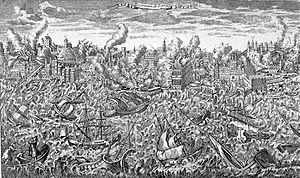
The best-known is perhaps the massive tsunami caused by the eruption of the Santorini volcano around 1600 BC, which is often mentioned as driving the destruction of many harbours in the region and ultimately the decline of Minoan civilization - a question still subject to open debate.
[48] Debate has persisted over the origins and source mechanisms of such tsunamis as those generated by Krakatoa in 1883,[48] and they remain lesser understood than their seismic relatives.
This poses the larger problem of awareness and preparedness, as exemplified by the eruption and collapse of Anak Krakatoa in 2018, which killed 426 and injured thousands when no warning was available.
[51][52] Some meteorological conditions, especially rapid changes in barometric pressure, as seen with the passing of a front, can displace bodies of water enough to cause trains of waves with wavelengths.
In spite of their lower energies, on shorelines where they can be amplified by resonance, they are sometimes powerful enough to cause localised damage and potential for loss of life.
They have been documented in many places, including the Great Lakes, the Aegean Sea, the English Channel, and the Balearic Islands, where they are common enough to have a local name, rissaga.
Some examples of destructive meteotsunamis include 31 March 1979 at Nagasaki and 15 June 2006 at Menorca, the latter causing damage in the tens of millions of euros.
Storm surges and setup are also dangerous causes of coastal flooding in severe weather but their dynamics are completely unrelated to tsunami waves.
As early as World War II (1939–1945), consideration of the use of conventional explosives was explored, and New Zealand's military forces initiated Project Seal, which attempted to create small tsunamis with explosives in the area of what is now Shakespear Regional Park at the tip of the Whangaparāoa Peninsula in the Auckland Region of New Zealand; the attempt failed.
In Operation Crossroads in July 1946, two 20-kilotonne-of-TNT (84 TJ) bombs were detonated, one in the air over and one underwater within the shallow waters of the 50-metre (164 ft) deep lagoon at Bikini Atoll.
The velocity of a tsunami can be calculated by obtaining the square root of the depth of the water in metres multiplied by the acceleration due to gravity (approximated to 10 m/s2).
The drawback can exceed hundreds of metres, and people unaware of the danger sometimes remain near the shore to satisfy their curiosity or to collect fish from the exposed seabed.
People who observe drawback (many survivors report an accompanying sucking sound) can survive only if they immediately run for high ground or seek the upper floors of nearby buildings.
Based on these pressure readings and other seismic information and the seafloor's shape (bathymetry) and coastal topography, the models estimate the amplitude and surge height of the approaching tsunami.
Along the United States west coast, in addition to sirens, warnings are sent on television and radio via the National Weather Service, using the Emergency Alert System.
The Fukushima Daiichi nuclear disaster was directly triggered by the 2011 Tōhoku earthquake and tsunami, when waves exceeded the height of the plant's sea wall and flooded the emergency generators.
[81] The Okushiri, Hokkaidō tsunami, which struck within two to five minutes of the earthquake on July 12, 1993, created waves 30 metres (100 ft) tall—as high as a 10-storey building.