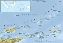
Damar Island
Together they are called the Damar Islands, and constitute one administrative district within the Maluku Barat Daya Regency, lying on the undersea ridge which forms the most easterly extension of the Lesser Sunda Islands.
The district has a combined land area of 201.80 km2 and had a population of 5,718 at the 2020 Census;[1] the official estimate as at mid 2023 was 6,362, all on Damer Island itself.
[3] The highest point of the island is 868 m (2,847 ft) Mount Wurlali, an andesitic stratovolcano.
The island is administratively divided into seven villages (desa), listed below with their officially-estimated populations as at mid 2022,[5] together with their postcodes.
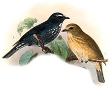
The forested part of the island has been identified by BirdLife International as an Important Bird Area because it supports the endemic Damar flycatcher, which is largely restricted to lowland evergreen forest habitat.