Danish Expedition to Queen Louise Land
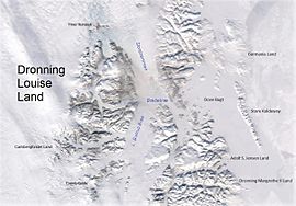
The first phase of the expedition was reaching Queen Louise Land, a nunatak region located on the edge of the Greenland Ice Sheet, and the building of a wintering station there.
In the spring of 1913 the members of the expedition left their base and headed westwards on an approximately 1,200 km (750 mi) long journey, crossing the Greenland Ice Sheet and reaching the western shore near Kangersuatsiaq, former Prøven.
Meanwhile the surface of the Borg Fjord began to freeze, but the expedition had to wait until the ice was strong enough for the weight of the ponies and the sledges, which took a further three weeks.
Thus, on 12 October the house was built on the last stretch of Storstrommen, off the Borgjokel terminus at 76°42′N 22°24′W / 76.700°N 22.400°W / 76.700; -22.400, 14 km (8.7 mi) west of the eastern edge of Queen Louise Land.
[1] On the 21 April in the evening the expedition members left their base and began their great journey westwards on the five ponies and five sledges that remained.
Two of the ponies had to be shot because they refused to go forward and Wegener seriously wondered in his diary whether any of the expedition members would reach the west coast of Greenland alive.
The average daily distance covered was around 20 km (12 mi) in optimal conditions, However on the third week of June they had to interrupt the progress of the caravan owing to a violent storm and had to wait for days until it abated.
In mid July the men reached the shore of the Lakse Fjord (Eqalugaarsuit Sulluat) where they sighted a ship and made signals with one of the sails of the sleds.
[3][2] In 1913 itself, just months after the end of the venture, J.P. Koch published the expedition's travel journal Gennem den hvide ørken (Through the White Desert), which became a popular book.
Shortly after the First World War Wegener published a German edition of the same book under the title Durch die weiße Wüste, meaning "Across the White Desert" as well.
Innovative photography techniques were used and the polar region Fata Morgana phenomenon was photographed for the first time with the help of a special telescope camera.
[6] J.P. Koch had designed the Borg wintering station as a well-built solid house, with an attached stable for the ponies, that could withstand the violent storms of the area.
Unfortunately in the end it had to be built over the glacier ground to the east because of the harsh ice conditions that made the transport of the heavy building materials further to the west impossible and winter was fast approaching.
The abandoned station was thus subject to the roughly southeastward movement of the glacier and eventually fell into the waters of the Borg Fjord during a calving event.
Owing to numerous difficulties this venture would claim Wegener's life during a return trip from the station together with expedition member Rasmus Villumsen.