De Virga world map
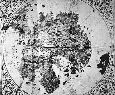
[1] The map is oriented to the north, with a wind rose centered in Central Asia, possibly the observatory of Ulugh Beg in the Mongol city of Samarkand in Uzbekistan, or the western shore of the Caspian Sea.
The extension shows a calendar with depictions of the signs of the zodiac and a table to calculate lunar positions.
[2] Africa contains depictions of the Atlas Mountains and the Nile river, with mention of the territory of Prester John ("Pre.
The Garden of Eden is depicted at the southernmost tip of Africa with the symbol of two concentric rings, from which emerge the four rivers mentioned in Genesis.
The locations described in Asia are consistent with Mongolian rule: Medru, Calcar, Monza sede di sedre ("the Mangi of northern China"), and Bogar Tartarorum ("the Great Bulgarian" or "Golden Horde").
[3] In northern Europe, various places are mentioned, such as "Ogama, Goga" Gog and Magog, "Rotenia" Russia, Naia, Samolica, and a peninsula or promontory showing the southern end of "Norveca" Norway.
[4] The map was re-discovered in a second-hand bookshop in 1911 in Šibenik, Croatia by Albert Figdor, an art collector.