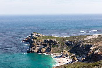
Cape of Good Hope
When following the western side of the African coastline from the equator, however, the Cape of Good Hope marks the point where a ship begins to travel more eastward than southward.
[7][8] Herodotus' account was handed down to him by oral tradition,[9] but is seen as potentially credible because he stated with disbelief that the Phoenicians "as they sailed on a westerly course round the southern end of Libya (Africa), they had the sun on their right"—to northward of them (The Histories 4.42).
In or about 116 BCE, while returning from a voyage to India, Eudoxus found the wreck of a ship that appeared to have originated in Gades (later Cádiz), in what was then Roman Hispania Baetica.
When Eudoxus was returning from his second voyage to India, the wind forced him south of the Gulf of Aden and down the coast of Africa for some distance.
Due to its appearance and the story told by the natives, Eudoxus concluded that the ship was from Gades and had sailed anti-clockwise around Africa, passing the Cape and entering the Indian Ocean.
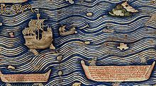
They can navigate without a compass, because they have an astrologer, who stands on the side and, with an astrolabe in hand, gives orders to the navigator.—Text from the Fra Mauro map, 09-P25Fra Mauro explained that he obtained the information from "a trustworthy source", who traveled with the expedition, possibly the Venetian explorer Niccolò da Conti who happened to be in Calicut, India at the time the expedition left: What is more, I have spoken with a person worthy of trust, who says that he sailed in an Indian ship caught in the fury of a tempest for 40 days out in the Sea of India, beyond the Cape of Soffala and the Green Islands towards west-southwest; and according to the astrologers who act as their guides, they had advanced almost 2,000 miles.
Thus one can believe and confirm what is said by both these and those, and that they had therefore sailed 4,000 miles.Fra Mauro also comments that the account of the expedition, together with the relation by Strabo of the travels of Eudoxus of Cyzicus from Arabia to Gibraltar through the southern Ocean in Antiquity, led him to believe that the Indian Ocean was not a closed sea and that Africa could be circumnavigated by her southern end (Text from Fra Mauro map, 11, G2).
This knowledge, together with the map depiction of the African continent, probably encouraged the Portuguese to intensify their effort to round the tip of Africa.
Regarding the chart Albuquerque said:[17][18]: 98–99 "...a large map of a Javanese pilot, containing the Cape of Good Hope, Portugal and the land of Brazil, the Red Sea and the Sea of Persia, the Clove Islands, the navigation of the Chinese and the Gores, with their rhumbs and direct routes followed by the ships, and the hinterland, and how the kingdoms border on each other.
I send this piece to Your Highness, which Francisco Rodrigues traced from the other, in which Your Highness can truly see where the Chinese and Gores come from, and the course your ships must take to the Clove Islands, and where the gold mines lie, and the islands of Java and Banda, of nutmeg and mace, and the land of the King of Siam, and also the end of the land of the navigation of the Chinese, the direction it takes, and how they do not navigate farther.
[19] It was later renamed by John II of Portugal as "Cape of Good Hope" (Cabo da Boa Esperança) because of the great optimism engendered by the opening of a sea route to India and the East.
Supplies of fresh food were vital on the long journey around Africa and Cape Town became known as "The Tavern of the Seas".
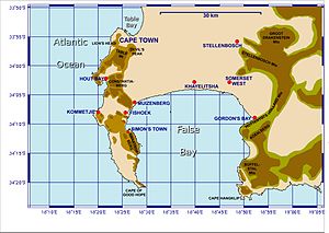
When lined up, these crosses point to Whittle Rock, a large, permanently submerged shipping hazard in False Bay.
[34][35][36][37] The Cape of Good Hope route took a toll on the sea freight industry—stretching the transit time, reducing carriers availability, and skyrocketing shipment cost and container hire.
[45] With its diverse habitat, ranging from rocky mountain tops to beaches and open sea, the Cape of Good Hope is home to at least 250 species of birds including one of the two mainland colonies of African penguins.
The Cape of Good Hope section of Table Mountain National Park is home to several species of antelope.
Small mammals include rock hyrax, four-striped grass mouse, water mongoose, Cape clawless otter and fallow deer.
The strategic position of the Cape of Good Hope between two major ocean currents, ensures a rich diversity of marine life.
Disturbance or removal of any marine organisms is strictly prohibited between Schusters Bay and Hoek van Bobbejaan, but is allowed in other areas during season and with relevant permits.
[citation needed] Chacma baboons (Papio ursinus) are the mammals most intimately associated with the Cape of Good Hope.
Chacma baboons are widely distributed across southern Africa and are classified as "least concern" in the IUCN Red List of Threatened Species.
However, the South African Parks Department states in its publication Mountains in the Sea that the baboon population on the Cape is "critically endangered."
[46] In 1842, Charles Hamilton Smith had described a black-maned lion from the Cape under the scientific name Felis (Leo) melanochaita.