Campine
The Campine (French: [kɑ̃pin] ⓘ) or Kempen (Dutch: [ˈkɛmpə(n)] ⓘ) is a natural region situated chiefly in north-eastern Belgium and parts of the south-eastern Netherlands which once consisted mainly of extensive moors, tracts of sandy heath, and wetlands.
The region, described as a desolate flat land, often appears in the books of the prominent Flemish writer Hendrik Conscience (1812–1883), who spent much of his childhood there.
The Museum Kempenland in Eindhoven has a considerable and historically important art collection of painters, draughtsmen, sculptors, blacksmiths and other craftsmen from this region.
The Campine Basin, which extends from Belgium into the Netherlands, is formed by the Devonian and Carboniferous sedimentary rocks on the northern flank of the Brabant Massif.
Most of those cities are located at the outer rim of the region, such as Hasselt, Diest, Aarschot, Lier (the self-styled gate of the Campine, a title also claimed by the Northern-Brabant Oirschot), Breda, Tilburg, Eindhoven, Maaseik, and Maastricht.
The region was sparsely populated, and therefore chosen by monks who were looking for silence, such as those of the abbeys of Achel, Brecht, Zundert, Postel, Westmalle and Tongerlo.
In 1872, the Sablières et Carrières Réunies (SCR), now Sibelco, was founded to extract the silica sand layers in Mol for industrial applications (glass).
Due to the exploitation of the Campine coal basin, especially after World War II, new industrial activity was established, such as in Geel, Beringen and Genk.
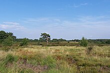
[6] Where the Campine, up to around 1960 includes mainly heathland, oak grove and marsh, these were modified by heavy fertilisation and building activities and were gradually changed into a rather small-scale landscape.
Here and there still up to several dozen acres of large heathland - and forests, such as the Kalmthoutse Heide (E: Kalmthout heathland) at Kalmthout, Belgium, the De Maten in Genk, De Zegge (Geel), Zwart Water (Lichtaart), the Zwart Water moors (Turnhout), the Liereman (Oud-Turnhout) and the Prinsenpark (Retie).
At the border with Belgium in the Dutch part of Campine near Bladel there is natural landscape area with heathland such as Cartierheide and De Pals and Kroonvense Heide.