Ardennes
The eastern part of the Ardennes forms the northernmost third of the Grand Duchy of Luxembourg, also called "Éislek" (German: Oesling).
The strategic position of the Ardennes has made it a battleground for European powers for centuries; it was the site of major battles during both World Wars.
The Eifel range in Germany adjoins the Ardennes and is part of the same geological formation, although they are conventionally regarded as being two distinct areas.
The region the Ardennes are part of has been uplifted further in the last few hundred thousand years by a mantle plume, as measured from the present elevation of old river terraces, with the largest amount of uplift concentrated in the east, where the Ardennes connect with the Eifel, where the same mantle plume is also responsible for volcanic activity.
Some geological stages internationally recognized were defined from rock sites located in Wallonia: e.g., Frasnian (Frasnes-lez-Couvin), Famennian (Famenne), Tournaisian (Tournai), Visean (Visé), Dinantian (Dinant), and Namurian (Namur)".
The scenic beauty of the region and its wide variety of outdoor activities, including hunting, cycling, walking and canoeing, make it a popular tourist destination.
[citation needed] The modern Ardennes region covers a greatly diminished area from the forest recorded in Roman times.
A song about Charlemagne, the Old French 12th-century chanson de geste Quatre Fils Aymon, mentions many of Wallonia's rivers, villages and other places.
In 1815, the Congress of Vienna, which dealt with the political aftermath of the Napoleonic Wars, restored the previous geographical situation, with most of the Ardennes becoming part of the Grand Duchy of Luxembourg.
The military strategists of Nazi Germany in 1939 and 1940 selected the forest as the primary route of their mechanized forces in the Invasion of France.
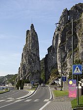
Under the command of General Heinz Guderian,[7] the German armoured divisions crossed the river at Dinant and at Sedan, France.
After a fierce battle the Allied forces blocked the German advance on the river Meuse at Dinant.In the postwar period, the Ardennes has become a weekend retreat that is popular among both Belgians and the neighboring countries.