Death Valley
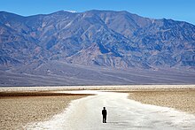
[3] Death Valley's Badwater Basin is the point of lowest elevation in North America, at 282 feet (86 m) below sea level.
[1] It is 84.6 miles (136.2 km) east-southeast of Mount Whitney – the highest point in the contiguous United States, with an elevation of 14,505 feet (4,421 m).
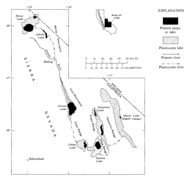
[7] Lying mostly in Inyo County, California, near the border of California and Nevada, in the Great Basin, east of the Sierra Nevada mountains, Death Valley constitutes much of Death Valley National Park and is the principal feature of the Mojave and Colorado Deserts Biosphere Reserve.
[9] The highest point in Death Valley National Park is Telescope Peak, in the Panamint Range, which has an elevation of 11,043 feet (3,366 m).
[10] A group of European-American pioneers got lost here in the winter of 1849–1850, while looking for a shortcut to the gold fields of California, giving Death Valley its grim name.
[13] It lies at the southern end of a geological trough, Walker Lane, which runs north to Oregon.
Moisture moving inland from the Pacific Ocean must pass eastward over the mountains to reach Death Valley; as air masses are forced upward by each range, they cool and moisture condenses, to fall as rain or snow on the western slopes.
[16] The extreme heat of Death Valley is attributable to a confluence of geographic and topographic factors.
Scientists have identified a number of key contributors:[16] Severe heat and dryness contribute to perpetual drought-like conditions in Death Valley and prevent much cloud formation from passing through the confines of the valley, where precipitation is often in the form of a virga.
The valley is a long, narrow basin that descends below sea level and is walled by high, steep mountain ranges.
The clear, dry air and sparse plant cover allow sunlight to heat the desert surface.
Moving masses of super-heated air blow through the valley, creating extremely high ambient temperatures.
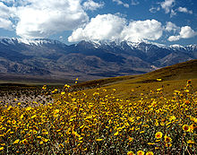
[19] The wettest period on record was mid-2004 to mid-2005, in which nearly 6 inches (150 mm) of rain fell in total, leading to ephemeral lakes in the valley and the region and tremendous wildflower blooms.
In 2005, Death Valley received four times its average annual rainfall of 1.5 inches (38 mm).
By May 2005, the valley floor had resumed its more familiar role as Badwater Basin, salt-coated salt flats.
During flash floods, rainfall from the steep mountains to the west pours through narrow canyons, picking up everything from fine clay to large rocks.
In spite of the overwhelming heat and sparse rainfall, Death Valley exhibits considerable biodiversity.
Death Valley National Monument was proclaimed on February 11, 1933, by President Herbert Hoover, placing the area under federal protection.