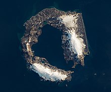
Deception Island
Just inside Neptune's Bellows lies the cove Whalers Bay, which is bordered by a large black sand beach.
Three of five population growth phases were terminated by a sudden crash, due to volcanic eruptions from the active volcano of Deception Island.
The island is associated with Bransfield Basin seafloor spreading that includes a volcanic ridge and seamounts dating back to the Pleistocene.
The caldera collapsed as either a hydrovolcanic eruption of the Outer Coast Tuff Formation, releasing about 30 cubic kilometers of magma, or passively due to regional tectonics, since the island is at the intersection of the Bransfield Strait rift and the orthogonal Hero fracture zone.
[12][13] Palmer was part of an American sealing fleet from Stonington, Connecticut, under the command of Benjamin Pendleton, consisting of 6 ships.
While the island did not have a large seal population, it was a perfect natural harbour, mostly free from ice and winds, and a convenient rendezvous point.
Some men likely lived ashore in tents or shacks for short periods during the summer, though no archaeological or documentary evidence survives to confirm this.
[3] In 1829, the British Naval Expedition to the South Atlantic under the command of Captain Henry Foster in HMS Chanticleer stopped at Deception.
[11] A subsequent visit by the American elephant-sealer Ohio in 1842 reported the first recorded volcanic activity, with the southern shore "in flames".
In 1906, the Norwegian-Chilean whaling company Sociedad Ballenera de Magallanes started using Whalers Bay as a base for a single ship, the Gobernador Bories.
[18] These were not the only constructions; as the factory ships of the period were only able to strip the blubber from whales and could not use the carcasses, a permanent on-shore station was established by the Norwegian company Hvalfangerselskabet Hektor A/S in 1912 – up to an estimated 40% of the available oil was being wasted by the ship-based system.
This rapidly led to overproduction of oil and a collapse in the market, and the less profitable and more heavily regulated shore-based companies had trouble competing.
[19] In 1944, a British expedition under Lieutenant James Marr[20] established a short-lived base on Deception Island as part of Operation Tabarin, which was carried out during the Second World War to deny safe anchorages to enemy raiding vessels and to gather meteorological data for allied shipping in the South Atlantic.
Following the end of the war, the research begun by Operation Tabarin continued in subsequent years, ultimately becoming the British Antarctic Survey.
[22] In February 1953, as part of a post-war British effort to exert sovereignty over its claimed Antarctic territories, HMS Snipe (U20) landed a party of Royal Marines on Deception Island to destroy an Argentinian and a Chilean military base; an action known as the Deception Island incident.
A bright orange derelict airplane fuselage, which is that of a de Havilland Canada DHC-3 Otter that belonged to the Royal Air Force, was recovered in 2004.
She later became a ghost ship in the North Atlantic after the towing line parted during an operation to scrap the vessel in the Dominican Republic.
[29] The Gutiérrez Vargas Refuge, named after an aviation captain who died on 30 December 1955, was located at 1 km (0.62 mi) from Aguirre Cerda Station and was inaugurated on 12 February 1956.
[citation needed] In early 1944, a party of men from Operation Tabarin, a British expedition, established a permanent scientific base named Station B.
[25](p 291–292) Deception Island has become a popular tourist stop in Antarctica because of its several colonies of chinstrap penguins, as well as the possibility of making a warm bath by digging into the sands of the beach.
After the Norwegian Coastal Cruise Liner MS Nordkapp ran aground off the coast of Deception Island on 30 January 2007, fuel from the ship washed into a bay.
This is largely due to frequent volcanic activity creating new substrates for plant colonisation:[31] In addition, two marine sites in Port Foster have collectively been designated ASPA 145, to protect their benthic communities.
[32] Baily Head, a prominent headland forming the easternmost extremity of the island, has been identified as an important bird area (IBA) by BirdLife International because it supports a very large breeding colony of chinstrap penguins (100,000 pairs).