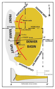
Denver Basin
The basin consists of a large asymmetric syncline of Paleozoic, Mesozoic, and Cenozoic sedimentary rock layers, trending north to south along the east side of the Front Range from the vicinity of Pueblo northward into Wyoming.
Farther west, the Fountain Formation outcrops as flatirons and forms the namesake of the Red Rocks Park and Amphitheatre.
The basin started forming as early as 300 million years ago, during the Colorado orogeny that created the Ancestral Rockies.
[1] The basin was most likely further deepened in Paleogene time, between 66 and 45 million years ago, during the Laramide orogeny that created the modern Colorado Rockies.
In particular, the uplifting of the Rockies in the Front Range caused the crust near Denver to buckle downward on the eastern side, deepening the basin.
The Front Range peaks rise approximately 22,000 ft (6600 m) from the floor of the basin under Denver.
In the regions to the north and south of Denver, however, stream erosion removed the Paleogene layers, revealing the underlying Cretaceous Pierre Shale.
Oil has also been produced from Permian sandstones and dolomites and Pennsylvanian limestones in the Nebraska part of the basin.
[16] Raw materials are mined from the Niobrara Formation and Pierre Shale and made into cement at the Cemex plant near Lyons, Colorado.
The Lyons Formation provides flagstone from quarries in Boulder and Larimer counties, along the western edge of the basin.