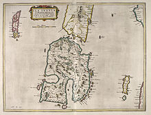
Description of the Western Isles of Scotland
Although Monro was criticised for publishing folklore and for omitting detail about the affairs of the churches in his diocese, Monro's Description is a valuable historical account and has reappeared in part or in whole in numerous publications, remaining one of the most widely quoted publications about the western islands of Scotland.
The Sibbald manuscript also contains details about the "Council of the Isles" that operated from Eilean na Comhairle in Loch Finlaggan on the island of Islay.
This is the most detailed extant account of the supreme judiciary body that had existed under the Lordship of the Isles until its demise in the late fifteenth century.
[9] These were troubled times in the Highlands and Islands, with Domhnall Dubh's attempts to resurrect the Lordship of the Isles only failing on his death in 1545.
Partly as a result, the See of the Isles was one of the poorest in Scotland and although Monro lists fourteen islands as belonging to its Bishop, in practice rents were hard to collect.
He referred to himself as "High Dean of the Isles"[13] and his position was one of considerable influence although the advancing Reformation added further complication to the political landscape in which he was operating.
In 1560 the new Confession of Faith was adopted and ten dioceses were created anew, with the Isles shared between Ross and Argyll.
Monro converted to Protestantism and was admitted to the new ministry for the parish of Kiltearn, to which he later added the adjacent Lemlair and Alness.
[17] In or shortly before 83 AD, a traveller called Demetrius of Tarsus related to Plutarch the tale of an expedition to the west coast of Scotland.
[19] In his Natural History Pliny the Elder states that there are 30 "Hebudes", and makes a separate reference to "Dumna", which Watson (1926) concludes is unequivocally the Outer Hebrides.
[20][21][22] The first written records of native life in the Hebrides begin in the 6th century AD with the founding of the kingdom of Dál Riata.
[23] Much of what is known of these times is the product of the monastic sites such as Iona, Lismore, Eigg and Tiree but north of Dál Riata, where the Inner and Outer Hebrides were nominally under Pictish control, the historical record is sparse.
[27][28] In 1603 the portion in Scots relating to the islands was published in Certayne Matters concerning the Realme of Scotland edited by John Monipennie[28] of Pitmilly in the parish of Kingsbarns, Fife.
[30] The original version of Monro's text has been lost, but a copy made in 1642 by Sir James Balfour of Denmilne and Kinnaird, is still extant.
Entitled Description of the Occidental i.e. Western Isles of Scotland by Mr Donald Monro who travelled through the most of them in Anno 1549 it was acquired by the Advocates Library in Edinburgh in 1733.
[31] Monro's work first came to a wider public when the incomplete version of Description was published in 1774 by William Auld of Edinburgh, along with some supplementary writing about the Hebrides.
The shorter list was re-published (without the Genealogies) by Peter Hume Brown in his Scotland before 1700, from Contemporary Documents in 1893 and for the first time the text was subject to scrutiny by a professional historian.
[5] R. W. Munro's 1961 re-publication includes the full text of the Sibbald manuscript (MS), a comparison with the shorter Balfour/Auld versions, the recovered text of Monro's description of the Council of the Isles at Finlaggan,[4] George Buchanan's preface to Description in Rerum Scoticarum Historia and scholarly accompanying material.
[5] Monro originally wrote in Scots, and some of the descriptions are difficult to render into modern English without a working knowledge of this archaic style.
With the exception of Lismore, Monro's "descriptions" in this section are little more than a name recorded in English and "Erische" (i.e. Gaelic), which makes definitive identifications hard to achieve.
There are also numerous other small islands with these names in this vicinity and it is an odd coincidence that numbers 39–41 all have strong contenders in Loch Craignish, as identified by R. W.
It is possible Pont knew of Monro's work and added a few islets on this basis[75] and the correspondence with modern maps and names is not clear in some instances.
72 is "Hessil" is also "Ellan Natravie" in the Auld version,[76] which names hints at a pronunciation of the Gaelic for "beach" yet Monipennie has "Colurna" and R. W. Munro identifies the island as possibly being Eilean Craobhach.
"[97] John Lorne Campbell (1936) states that Monro "apparently had visited Barra, but it is clear that he writes of the smaller islands from hearsay alone".
[105] It incorporates Lewis in the north and Harris in the south, both of which are frequently referred to as individual islands, although they are joined by a land border.
[122] Monipennie provides a slightly longer text as a translation from Buchanan about the government of the Isles that operated from Eilean na Comhairle at Finlaggan.
[Note 16] Monro describes the membership of the Council, comprising "14 of the Iles best Barons" and its role as the supreme court of justice.