Desert Fireball Network
Starting in 2018, cameras deployed across the world began the first global fireball observatory in association with partner research teams.
Based on the long-exposure images, trajectories and orbits are plotted in a semi-automated manner, and a fall-line is generated to indicate the whereabouts and mass of any resultant meteorites on the ground.
[1][2][3] When the meteorite is found and collected, a myriad of analyses can take place that shows what conditions were like on the parent body and what has happened to the rock over its lifetime.
[1] The interest in this approach heightened in 2008 when a telescopic astronomical sky survey detected a meteoroid on an Earth-bound trajectory, and successfully pinpointed its location on the Earth's surface.
A connection between the candidate asteroid type and the meteorite was made based on the object's composition and orbit, but such observatories only see a small portion of the sky, and so the likelihood of observing such events regularly is somewhat low.
[1] As soon as the network was running, meteors were being observed, and on the first recovery trip, and on the very first day, the meteorite was found only 100 m from the predicted fall line.
This means the processes occurring deep within asteroids can be learned fairly easily, and knowledge about the composition of the inner core of Earth can be based on these rocks.
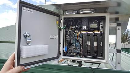
[1][2] The DFN observatories use consumer still photographic cameras (specifically DSLRs) with 8mm stereographic fish-eye lenses covering nearly the entire sky from each station.
A wireless link to each Automated Fireball Observatory allows a cross-check for multi station confirmation and enables images to be remotely downloaded.
These are converted to celestial coordinates, to a minute of arc precision, by using a powerful astrometric calibration tool created to automatically identify surrounding stars, and use them as a referencing system.
This provides accurate, absolute timing information for the duration of the trajectory to 0.4 ms. Purpose written software uses entry parameters to determine orbits for each meteoroid.
Data from the Global Forecasting System is used in an atmospheric wind model with a 0.008 degree resolution mesh uniquely created around the area of the fireball.
A Monte Carlo dark flight simulation is performed to determine a likely search area for main mass and fragments.
Most of the falls observed by the DFN are in the remote outback, and so searching teams usually consist of 4-6 people, who camp on site for up to two weeks.
Through augmented reality, an intuitive interface and sensing technology of a smartphone app, anyone anywhere in the world can recreate their fireball sighting to contribute scientifically useful data.
It is currently the best available system for reporting accurate public fireball sighting in the world, and feeds directly into the database of the DFN.
Together with NASA, the DFN is expanding to a Global Fireball Observatory through the Solar System Exploration Research Virtual Institute (SSERVI).