The term was introduced by Romanian geologist Ludovic Mrazek, who was the first to understand the principle of salt tectonics and plasticity.
[5] Diapirs commonly intrude buoyantly upward along fractures or zones of structural weakness through denser overlying rocks.
[6] Rock types such as evaporitic salt deposits, and gas charged muds are potential sources of diapirs.
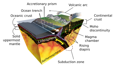
Diapirs also form in the Earth's mantle when a sufficient mass of hot, less dense magma assembles.
Diatremes are not usually associated with diapirs, as they are small-volume magmas which ascend by volatile plumes, not by density contrast with the surrounding mantle.
Geological cross section through the Northwestern Basin of Germany (Ostfriesland-Nordheide). Salt domes have penetrated younger layers and moved near to the surface. They sometimes form pockets where petroleum and natural gas can collect. Excavated salt domes are also used for underground storage.
Astronaut photo of the southwestern edge of the
Zagros Mountains
featuring the
Jashak salt dome
(white spot in center). Erosion revealed the uplifted tan and brown rock layers surrounding the salt dome to the northwest and southeast (center of image). Radial drainage patterns indicate another salt dome is located to the southwest (image left center).
A map of salt domes that penetrate the base of layer 9 (permeable zone C) in the gulf of Mexico off the Louisiana coast.
[
10
]
Satellite imagery of salt domes and salt glaciers, visible as darkish irregular patches, Zagros Mountains, southern Iran, near
Karmowstaj
. Gravity has caused the salt to flow like glaciers into adjacent valleys. The resulting tongue-shaped bodies are more than 5 kilometers long. The darker tones are due to clays brought up with the salt, as well as the probable accumulation of airborne dust.