Difficult Run
Difficult Run is a 15.9-mile-long (25.6 km)[1] tributary stream of the Potomac River in Northern Virginia in the United States.
It was named by long-boatmen in the time of the Patowmack Company, who found the two sharp bends of the Potomac near Difficult Run's mouth treacherous.
[3] General Braddock utilized the old highway during the French and Indian Wars where he marched his troops throughout the road on their way to Fort Duquesne.
There are various other sites along the trail, which include Drover's Rest, Old Quarry, Old Dominion Drive Bridge, Colvin Run Village, and Day Family Cemetery.
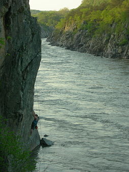
The seven rapids that occur in the stream all have classifications that range from Class III to V.[5] The Difficult Run is also famously known for its views of the Potomac and Mather Gorge cliffs.
Additionally, Difficult Run offers access to Great Falls National Park from certain areas of the trail, adding to the options for recreational activity.
Using community planning, a secluded 12-mile (19 km) hiking and biking trail was built along Difficult Run from Reston to Great Falls Park.
The trail is well known among area mountain biking enthusiasts for its rolling terrain which makes for fast, smooth rides although there are portions requiring technical skills.
The portion of the trail that sees the most mountain biking activity starts near the end of Michael Faraday Court, behind SkateQuest-Reston ice skating rink and follows the tributary stream valley to Lake Fairfax.
From Lake Fairfax the trail crosses over Hunter Mill Road and follows Difficult Run itself all the way to Great Falls Park.
While fishing is allowed at Great Falls National Park and Difficult Run, a license is required for fishermen 16 years or older.
A series of rapids starting at the Difficult Run Georgetown Pike entrance will lead to directly into the Potomac River.
Muskrat and beaver can be found in the stream which runs adjoined to the trail which empties into the river known to provide habitation for various fish.
[6] In the region where Difficult Run trail is found, birds such as the Scarlet Tanager and Kentucky Warbler inhabit the environment during the Spring months.
The scenic trail starts near Georgetown Pike and ends where the difficult run stream meets the Potomac River.
Hikers, cyclists and horseback riders can make connections using Difficult Run to get to the Fairfax Cross Country Trail.
[4] The stream is member to a 57.7- square-mile watershed located in the north-central portion of Fairfax County and drains directly to the Potomac River.
[11] The water is crossed by several major highways, including Leesburg Pike, I-66, Route 50, the Dulles Access Road, and by the W&OD Trail.
In 1993 Fairfax Relief and the Virginia Soil and water conservation district planted 1,109 native hardwoods as a part of a restoration project on a large flood plain for the main stem of the Difficult run stream.
Another soil problem found in this area is naturally occurring asbestos fibers that have weathered off of greenstone bedrock.
This conservation can help stop landslides, corrosion, and contamination by metals[13][14] All locations are in Fairfax County, Virginia.