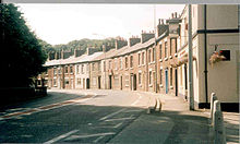
Disley
[1][2] It is located on the edge of the Peak District in the Goyt Valley, south of Stockport and close to the county boundary with Derbyshire at New Mills.
[3] To the north, the River Goyt and the Peak Forest Canal, which opened in 1800, pass along the edge of the village.
[4] Its Anglo-Saxon name was Dystiglegh, meaning "wood or clearing by a mound" or possibly "windy settlement".
[5] In the 13th century, in the time of Edward I, there are references to confirmatory grants of land made to Jordan de Dystelegh of Disley Hall and Roger de Stanley-de-Dystelegh of Stanley Hall in the district, pointing to even older local settlements.
Some residents believed that the village would be better served if it were part of the neighbouring boroughs of Stockport in Greater Manchester or High Peak in Derbyshire.
[7] On 8 May 2008, this referendum was held, with an overwhelming result in favour of staying within Cheshire; less than a third of electors wished to become part of the Metropolitan Borough of Stockport and an even lower proportion of the population wished the village to become part of High Peak Borough.
Lord John Hunt, who led the first successful Mount Everest expedition in 1953, also lived in Disley.
[16] High Peak Buses operates bus route 199, which provides a regular service between Buxton, New Mills, Stockport and Manchester Airport.
Moorside Golf Club, in Higher Disley, first appeared in the 1930s; it continued to operate until the late 1950s.
[21] Disley Golf Club, still in operation to the north of the village, opened in 1889 and is "one of the oldest inland courses in the UK".
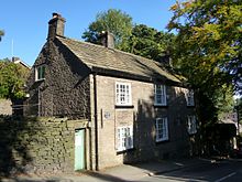
Part of the barn, also Grade II listed,[24] was used as the first clubhouse of the Disley golf club.