River Mersey
Its name derives from Old English and means "boundary river", possibly referring to its having been a border between the ancient kingdoms of Mercia and Northumbria.
[5] The Mersey Ferry operates between Pier Head in Liverpool and Woodside in Birkenhead and Seacombe, and has become a tourist attraction offering cruises that provide an overview of the river and surrounding areas.
The Mersey Valley Countryside Warden Service manages local nature reserves such as Chorlton Ees and Sale Water Park.
Prior to Anglo-Saxon conquest of the region, the river was almost certainly known by a Celtic name - recorded by Ptolemy as "Seteia" (as the Southern border of the Brittonic "Setantii" tribe).
[6] Some, including David Parsons, have suggested the original forms "Segeia" and "Segantii" - based on the root "sego" meaning "strong".
An early Ordnance Survey map indicates the spring at Red Hole on the border of Cheshire and Yorkshire at the head of one of the Etherow's longest headwaters, as being the Source of the River Mersey.
During the construction of the Manchester Ship Canal, the original course of the river through Wilderspool (which is north of Stockton Heath and Lower Walton) was diverted westward into a canalised section.
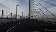
Another crossing, the Mersey Gateway road bridge opened in October 2017, and is situated about 1 mile upstream from the Runcorn Gap where the river is considerably wider.
From the Runcorn Gap, the river widens into a large estuary, which is 3 miles (4.8 km) wide at its widest point near Ellesmere Port.
American author Herman Melville described Liverpool Docks as being comparable to the pyramids in the vast scale of their construction.
Birkenhead grew quickly in the 19th century following the introduction of steamships, the earliest being the wooden paddle steamer Elizabeth in 1815.
[13] Taylor's Bank is a large sandbank extending out to sea on the north side of the channel entrance to the river on which many ships have come to grief over the years.
The majority of mariners to die worked on the Mersey flat boats and drowned due to the weather conditions or poor craft maintenance, although many ordinary civilians perished too.
Passengers had to traverse wooden planks over the mud flats to reach the ferry boats which themselves were often poorly maintained and leaking.
[5] At the same time the Silver Jubilee Bridge was closed to undergo maintenance for approximately 6–12 months, but will remain open to pedestrians and cyclists.
[26] Persistent organic and mercury (Hg) pollution contained within sediments of the Mersey estuary have been evaluated by British Geological Survey.
[27][28] Mersey river sediments from outer to inner estuary (Alfred Dock to Widnes) contain a variety of common organic pollutants, including polyaromatic hydrocarbons (PAH) with concentrations which fall in the middle of the range of similarly industrial-urban river-estuaries.
[27] The distribution of individual PAH compounds suggests that the Mersey has contaminants mainly derived from combustion sources such as vehicle exhaust as well as coal burning.
The distribution of the toxic heavy metal Mercury (Hg) has been assessed by measuring 203 sediments taken from shallow cores (0.4 – 1.6 m) extracted from both the main river and adjacent salt marshes.
[30] Atlantic grey seals from Liverpool Bay occasionally venture into the estuary[31] along with bottlenose dolphin and harbour porpoise.
Until the early 20th century, commercial traffic bound for further upstream carried cargo in large flat-bottomed sailing barges known as Mersey Flats to Howley Wharf in Warrington and (via the Sankey Canal) to St Helens.
Motor barges delivered to riverside factories at Warrington until at least the 1970s, but nowadays only pleasure craft and yachts use the upper estuary and the tidal river where a number of sailing clubs are based.
On most high tides, seagoing yachts with masts raised can navigate as far upstream as Fiddlers Ferry – about 3.1 mi (5.0 km) downstream of Warrington – where there is a small marina accessed via a river lock.
Before construction of the ship canal, a lock bypassing Howley Weir allowed navigation further upstream via a straight "cut" avoiding a meander around Woolston.
[43] Liverpool Sailing Club located at Garston Coastal Park on the north bank of the estuary has a 1000 feet slipway giving access to river for water sports.
[citation needed] Angling has become popular on some stretches of the river as fish such as perch, barbel, grayling, carp, roach, chub, trout, pike, bream and dace have been caught.
[citation needed] The river has also faced problems regarding the poaching of fish despite a strict 'catch and release' policy imposed on anglers for ecological reasons which applies to most UK waterways.
[48] Notable musical artists who have performed at the event include Katie Melua, Shola Ama and Russell Watson.
[52] Proposals continue for the construction of the Mersey Barrage, a tidal scheme to generate electricity and create another crossing of the river.
In 1965 it was the subject of the top-ten hit single "Ferry Cross the Mersey" by Gerry and the Pacemakers, and a musical film of the same name.