Diu district
[8] The district is made up of Diu Island and two small enclaves of Simbor and Gogola, at the border with the state of Gujarat.
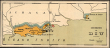
Mirroring the system of administrative division in Portugal, Diu district (Distrito de Diu) was established as an administrative division of the Portuguese State of India (Estado da Índia) in the first half of the 19th century.
In January 2020, the district became part of the new union territory of Dadra and Nagar Haveli and Daman and Diu.
The tiny territory of Simbor, located about 25 km east of the town of Diu, is also part of the district.
According to the 2011 census Diu district has a population of 52,074,[9] roughly equal to the nation of Saint Kitts and Nevis.
Major cities like Mumbai, Ahmedabad, Pune, Jabalpur (Madhya Pradesh), Dwarka and Thiruvananthapuram are directly connected to Veraval Railway Station.
Due to constant invasions from neighboring kingdoms as well as distant powers, the Portuguese built several fortifications all over the district.


1. Churches of St. Paul and St. Thomas (Diu)
2. Church of St. Francis of Assisi (Diu)
3. Church of Our Lady of Remedes (Fudam)
4. Church of Our Lady of Mercy (Vanakbara)