Dixie Fire
The 2021 Dixie Fire was an enormous wildfire in Butte, Plumas, Lassen, Shasta, and Tehama counties in Northern California.
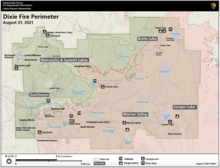
[4] Named after a nearby Dixie Road,[5] the fire began in the Feather River Canyon near Cresta Dam in Butte County on July 13, 2021, and burned 963,309 acres (389,837 ha) before it was declared 100 percent contained on October 25, 2021.
[22] The resulting overcrowded forests became more vulnerable to drought, as well as bark beetle infestations that were the primary cause of death for more than 163 million trees in California between 2010 and 2019.
[23] Bark beetle-affected forests (especially species common in the Sierra Nevada such as the lodgepole pine) are chemically altered, and the dead and dying trees are more flammable and more susceptible to intense crown fires.
[24] The Dixie Fire began on July 13, 2021, beneath a Pacific Gas and Electric (PG&E) 12-kilovolt power distribution line located on the northern side of the Feather River Canyon in a remote area above Highway 70 and Cresta Dam, midway between Paradise and Belden.
[27] At approximately 6:48 a.m. PDT a large Douglas fir, 65 feet (20 m) tall and 16 inches (41 cm) in diameter, fell onto the power line.
Noticing the two blown fuses, the troubleman was in the process of shutting off the third when he smelled smoke—looking down, he observed a fire approximately 600–800 square feet (56–74 m2) in size, burning among pine needles beneath the powerlines.
[25][29] By 5:15 p.m., the Oroville emergency command center had dispatched a full wildland response, including six fire engines, two bulldozers, two handcrews, two water tenders, two airtankers, and a helicopter.
Ground personnel, however, faced the same access issues that had plagued the PG&E troubleman, including the damaged bridge and rough dirt roads.
The drone's appearance meant about 45 minutes of flying time was lost, which Butte County district attorney Mike Ramsey said played a large role in the fire escaping control.
[35] Governor Gavin Newsom declared a state of emergency for Plumas, Butte, Lassen and Alpine counties due to the Dixie, Fly and Tamarack Fires.
[38] Firefighters successfully kept the fire north of Bucks Lake, while flames approached the Indian Valley communities of Crescent Mills, Greenville and Taylorsville on the east.
Later that night it merged with the smaller Fly Fire, which had started the previous day north of Quincy and burned over 4,300 acres (1,700 ha).
However, much of the growth was due to islands of unburned vegetation within the fire perimeter, as well as back burning operations to protect homes in Butte Meadows and Jonesville.
Beginning on August 3, after several days of calmer weather, a major wind event drove the fire up the west shore of Lake Almanor, threatening Chester and other nearby communities.
[44] On the evening of August 4, the northeast flank of the fire jumped containment lines at Indian Valley and burned through the town of Greenville.
The firestorm was compared to "a huge tornado" and took less than half an hour to destroy the town before leaping to the other side of Indian Valley and continuing northeast towards Mountain Meadows Reservoir.
The northern section of the fire expanded around the north side of Lake Almanor, heading east and south and threatening Westwood.
[10][11] In the evening of August 16, winds of up to 30 mph (48 kmh) drove embers from the Dixie Fire over the Diamond Mountains and into the Honey Lake Valley.
The next day, investigators responding to the Everitt Fire in a nearby part of the Shasta-Trinity National Forest noted identical tire tracks.
Maynard's arrest, and that of Alexandra Souverneva a month later for starting the destructive Fawn Fire near Redding, prompted many to downplay the role of climate change and spread rumors and conspiracy theories about the causes of California wildfires.
[65] On September 9 the weather became more favorable, especially in the West Zone, with calm winds, overnight temperatures down into the 30s, up to a quarter-inch of rain, and rising humidity resulting in minimal fire activity.
[72] On October 1, Devil's Punchbowl was devoid of heat based on infrared data and InciWeb indicated a 94 percent overall containment for the Dixie Fire (East and West Zone).
[73]The Dixie Fire resulted in the most expensive wildfire suppression effort in United States history, in part due to a reliance on contracted and higher-paid local and private firefighters.
[85] The Tásmam Koyóm valley that was returned to the Maidu as part of the Pacific Gas and Electric Company bankruptcy in 2019 lost a historic stagecoach stop and suffered damages to its cattle-grazing and culturally significant planting areas.
[87][88] By July 24 evacuation orders were extended to Greenville, Crescent Mills, Taylorsville, and other communities along the Feather River canyons east and west of the fire, as well as Bucks Lake, Meadow Valley and parts of Quincy.
[39] On August 3, Chester, Lake Almanor Peninsula and Hamilton Branch were evacuated as the fire advanced north toward Lassen National Park.
[12] On August 6 in Salt Lake City the small airborne particulates (PM2.5) level spiked to more than three times the federal standard, and caused the area to temporarily have the worst air quality in the world.
In early August, the Colorado Department of Public Health and Environment reported unhealthy air pollution levels in much of the state.
[105] On January 17, 2023, Shasta, Plumas, Lassen, Butte and Tehama counties and five other public entities impacted by the Dixie Fire announced that they had reached a $24 million settlement with PG&E.