Doggerland
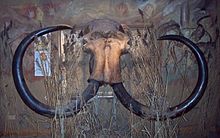
Interest intensified in 1931 when a fishing trawler operating east of the Wash dragged up a barbed antler point that was subsequently dated to a time when the area was tundra.
[6] As of 2020[update], international teams are continuing a two-year investigation into the submerged landscape of Doggerland using new and traditional archaeo-geophysical techniques, computer simulation, and molecular biology.
During the Anglian glaciation, about 450,000 years ago, an ice sheet filled much of the North Sea, with a large proglacial lake in the southern part fed by the Rhine, the Scheldt and the Thames.
This probably created the potential for Great Britain to become isolated from the continent during periods of high sea level, although some scientists argue that the final break did not occur until a second ice-dammed lake overflowed during the MIS8 or MIS6 glaciations, around 340,000 or 240,000 years ago.
The Seine, the Thames, the Meuse, the Scheldt, and the Rhine joined and flowed west along the English Channel as a broad, slow river before eventually reaching the Atlantic Ocean.
[6][11] One extensive river system found by a 3D seismic survey undertaken by the Birmingham "North Sea Palaeolandscapes Project" drained the southeastern part of the Dogger Bank hill area into the east end of the Outer Silver Pit lake.
[14] A recent hypothesis suggests that around 6200 BCE much of the remaining coastal land was flooded by a tsunami caused by a submarine landslide off the coast of Norway known as the Storegga Slide.
[22][23][24][25] Names have been given to some of its features: "The Spines" to a system of dunes above the broad "Shotton River", the upland area of the "Dogger Bank", a basin between two huge sandbanks called "The Outer Silver Pit".
[28] In 2019, a flint flake partially covered in birch bark tar dredged up off the coast of the Netherlands provided valuable insight into Neanderthal technology and cognitive evolution.
[29] In 2012, the results of a study of Doggerland by the universities of Birmingham, St Andrews, Dundee, and Aberdeen, including surveys of artefacts, were displayed at the Royal Society summer exhibition in London.
[30] Richard Bates of St Andrews University said:[30] We have speculated for years on the lost land's existence from bones dredged by fishermen all over the North Sea, but it's only since working with oil companies in the last few years that we have been able to re-create what this lost land looked like ... We have now been able to model its flora and fauna, build up a picture of the ancient people that lived there and begin to understand some of the dramatic events that subsequently changed the land, including the sea rising and a devastating tsunami.Since 2015, the University of Bradford's Europe's Lost Frontiers[31] project has continued mapping the prehistoric landscapes of Doggerland and has used this data to direct a programme of extensive coring of marine palaeochannels.
[35] Ancient artefacts have been found by beachcombers in material dredged from the sea bottom 13 km (8.1 mi) offshore and spread on a Dutch beach in 2012, as a coastal protection measure.