Dolaucothi Gold Mines
They are also the only known Roman gold mines in Britain, although it does not exclude the likelihood that they exploited other known sources in Devon in South West England, north Wales, Scotland and elsewhere.
Sextus Julius Frontinus was sent into Roman Britain in AD 74 to succeed Quintus Petillius Cerialis as governor of that island.
Objects found included a wheel brooch and snake bracelets, so named because they were soft enough to be coiled around the arm for display.
Evidence from the fortification (known as Luentinum from details given in Ptolemy's Geographia) and its associated settlement show that the Roman army occupied the fort from c. AD 78 to c. 125.
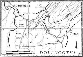
The Romans made extensive use of water carried by several aqueducts and leats, the longest of which is about 7 miles (11 km) from its source in a gorge of the river, to prospect for the gold veins hidden beneath the soil on the hillsides above the modern village of Pumsaint.
A smaller scale version of the same method is placer mining, and both may have been used to work alluvial placer deposits next to the river Cothi itself, judging by a large aqueduct which tapped the river a mile or so upstream, and enters the site at a low level compared with the other known aqueducts on the site.
One of the first aqueducts was built at a high level on the east slope of Allt Cwmhenog and tapped a small stream about 2 miles (3 km) away.
Yet the larger and longer aqueduct (with a gradient of 1 in 800) taps the River Cothi about 7 miles (11 km) to the north-east and traverses the same opencast, so must be later in date.
The water supply may have been obtained from a small leat run from a stream up the main Cothi valley before the much larger aqueduct was constructed.
Just by the road itself the Carreg Pumsaint has been erected in the space beside a large mound, now thought to be a dump of waste material from mining activities.
The existing ponds above and below the minor road from Pumsaint to Caeo, were probably part of a cascade for washing ore, the upper tank having yielded large quantities of Roman pottery from c. AD 78 to at least 300 (Lewis, 1977; Burnham 2004).
Since the fort and fortlet under the present village of Pumsaint ends in the middle of the 2nd century, it shows that mining continued for a long time after the military evacuation.
The ore was probably crushed on the famous Carreg Pumsaint, a block of stone erected many years ago before the Romans had left the site.
At Dolaucothi, a similar discovery was made in 1935 during mining operations, and it included part of a reverse overshot water wheel which is now in the National Museum of Wales.
A similar but larger wheel was rediscovered during mine operations at Rio Tinto in Spain, and is now in the British Museum, where it is displayed prominently in the Roman gallery.
Since the fragment of a reverse overshot water wheel was found 160 feet below any known adit or stope, it must have been part of a similar sequence at Dolaucothi to that in Spain.
Gold mining was sophisticated and technologically advanced at Dolaucothi, suggesting that the Roman army itself pioneered exploitation at the site.
The construction of such dewatering machines is described by the Roman engineer Vitruvius writing in 25 BC, and their use for irrigation and lifting water in thermae was widespread.
They are much wider than normal galleries, suggesting that their primary purpose was to allow circulation of air through the trench and permit safe fire-setting.
The Romans may have used slave labour taken from the local area to work the mine, although the army itself was probably most directly involved, especially for their engineering skills in surveying and building aqueducts, reservoirs and water tanks or cisterns.
Students from the School of Earth Sciences carried out an active gold exploration programme using surface and underground diamond drilling techniques, geochemical soil sampling and geophysics.
The mine was extensively mapped and a library of Dolaucothi data is still held at the School of Earth & Ocean Sciences at Cardiff University.
Cardiff University finally gave up the lease to the underground workings in 2000 due to the closure of its BSc Mining Engineering degree course.
Although there is yet no comparable site in Britain, it is likely that field work will locate other mines, simply by tracing the remains of aqueducts and reservoirs, and often, if not usually, aided by aerial photography.
The lead mines of Nantymwyn near Rhandirmwyn village some 8 miles (13 km) to the north may also have been first worked by the Romans, judging by hushing tanks and aqueducts found there in the 1970s both from fieldwork and aerial photographs.