Zaghouan Aqueduct
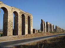
From its source in Zaghouan it flows a total of 132 km, making it among the longest aqueducts in the Roman Empire.
Sources mention a visit by the Emperor Hadrian in 128, with which a five-year-long drought is meant to have come to an end.
These facilities on the same scale as the Imperial baths in Rome demanded a steady supply of water, which could not be fulfilled with rainwater.
In Roman times a sacred fountain structure was built over the spring, which became one of the most important in ancient North Africa.
This wall continued from the ends of the crescent-shaped portico and was divided into 26 sections be engaged columns.
Including all its tributary channels, the aqueduct has a length of 132 km and is among the longest in the Roman empire.
The channel was built such that it had a steady, if not uniform, fall so that the water would travel the route by the force of gravity alone.
At regular intervals on the base of the channel, there were circular depressions, which served to purify the water, since detritus would settle in them.
To continue to operate, these had to be cleaned out regularly, so the channel required ongoing care and attention The distribution of the water within Carthage is not yet entirely clear.
The cistern of Bordj Djedid is made up of 18 barrel-shaped basins arranged in parallel and held between 25 and 30 million liters.
Since the water supply was essential for the city, the aqueduct was destroyed during the Vandal siege of 439, the Eastern Roman reconquest under Justinian and finally at the conquest of Carthage by the Arabs in 698, but each time it was subsequently restored.
In the thirteenth century, one of the Hafsid rulers added a branch leading to his palace in Manouba in order to supply water for his garden.
Since it was put into operation in 1862, the channel has remained in use and today it supplies an average of 12,000,000 L per day in winter and 3,000,000 in summer.
[1] The protected area extends over 40 ha as a band stretching near the Milliana river along the aqueduct 20-m-high pillars and arches in which many cavities and holes used by birds have developed.