Dollywaggon Pike
[1][2] One etymology for the word Dollywaggon gives an Old Norse source formed by the combination of dolgr (‘fiend’ or ‘giant’) and veginn (‘lifted’).
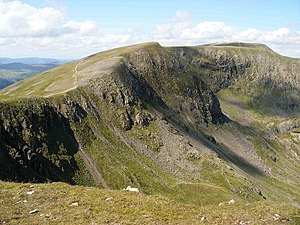
Due to the very limited depression between the two, most guidebooks follow Wainwright[4] in counting High Crag as a part of Nethermost Pike.
[citation needed] To the south of Dollywaggon Pike is the complex depression containing Grisedale Tarn, with Seat Sandal and Fairfield rising beyond.
In Wainwright’s words ‘To the west, uninteresting grass slopes descend to Dunmail Raise almost unrelieved by rock and scarred only by the wide stony track gouged across the breast of the fell by the boots of generations of pilgrims to Helvellyn.
But the eastern side is a desolation of crag and boulder and scree.’[4] The western flank is named Willie Wife Moor for reasons lost to antiquity.
The long strath of Grisedale runs north-eastward to Ullswater, cutting off a series of hanging valleys which fall from the Helvellyn range.
In the other direction the high ground curves south-east around Cock Cove before a long slope falls to Grisedale Tarn at around 1,770 feet (540 m).
Thus Seat Sandal stands topographically on the ridge between the two higher fells, but so out on a limb that many walkers proceed directly from Dollywaggon Pike to Fairfield.