Don River (Ontario)
Its mouth was just east of the street grid of the town of York, Upper Canada, the municipality that evolved into Toronto, Ontario.
The Don is one of the major watercourses draining Toronto (along with the Humber, and Rouge Rivers) that have headwaters in the Oak Ridges Moraine.
In 1788, Alexander Aitkin, an English surveyor who worked in southern Ontario, referred to the Don River as Ne cheng qua kekonk.
[2] This is an Anishnaabe phrase meaning the river coming from the back burnt grounds, which could refer to an earlier forest fire in the poplar plains to the north.
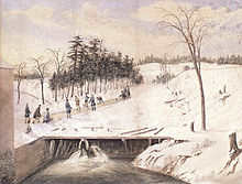
[5] While there is little archaeological evidence in the Don valley itself, regional finds in the Great Lakes St. Lawrence area have revealed that permanent settlements started to occur about 6000 BP.
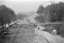
Known as "The Don Improvement Project", the straightened river was also supposed to divert the polluted waters into the Ashbridges Bay marsh.
[citation needed] Boats may still enter the Keating Channel by going underneath a lift bridge at Cherry Street.
[16] In 1946, a plan by the Shirriff company to demolish pioneer dwellings in the area of Todmorden Mills led outraged citizens to form the Don Valley Conservation Association volunteer organization.
[citation needed] The Association continued its activities, planting tree seedlings, halting the picking of wild flowers, particularly trilliums and preventing vandalism.
[citation needed] The authority had limited powers, and was funded by local municipalities which had to pay for specific land purchases.
For example, a 1950 plan to build a large conservation area on the East Don River at Milne Hollow at Lawrence Avenue never came to fruition over the high cost of development.
[10] Efforts to restore the Don gathered steam in 1989 with a public forum at the Ontario Science Centre which was attended by about 500 people.
[20] The result was the formation of the Task Force to Bring Back the Don, a citizen's advisory body to Toronto City Council.
Since then they have hosted garbage cleanups, tree plantings, and help to create or restore eight wetlands in the lower reaches of the valley, including Chester Springs Marsh, a 3 hectares (7.4 acres) site south of the Bloor Viaduct.
The project was also coupled with a plan to handle a major flood modeled on the expected output from a Hurricane Hazel size storm.
In 2007, the Toronto Waterfront Development Corporation (now WaterfrontToronto) held a design competition that looked at four different configurations for the mouth of the Don.
[28][29] Together with a series of accessible new entry points, the Master Plan calls for the reclamation of former green spaces throughout the valley, including the former snow dump site north of the Bloor Viaduct.
A "nature-inspired" public art program is set to launch in 2017, aiming to strengthen the cultural presence of the Don Valley, which—according to the Master Plan—already serves as a de facto backyard to some 250,000 Torontonians.
In 2018 City Council directed staff to consult community about naming the network of parks in the Lower Don "Wonscotonach Parklands", with Wonscotonach meaning "black burnt grounds" or "area previously swept by fire", deriving as an Anglicized form of the name "Waasayishkodenayosh" meaning "burning bright point" or "peninsula" in Anishinaabemowin.
[dubious – discuss] The Don River is now small in comparison to the deep and wide valley that resulted from its glacial origin.
The landscape at that time was loose glacial till so the large amounts of glacier melt water eroded deep valleys over thousands of years.
[34] Due to the urbanized nature of the watershed, the Don River experiences low base flows interspersed with high volume floods.
[36] On August 19, 2005, an unusually strong summer storm caused short term flooding in the Don Valley.
Since high flow rates occur during storm events, the resulting floods tend to scour the bottom of the river which reduces fish habitat.
In addition, the flood waters carry a large amount of sediment washed into the river from surrounding tablelands.
The western branch starts Vaughan, in the Maple district; flowing south-east through the suburban industrial area of Concord, and the G. Ross Lord Reservoir.
To control flooding from the Don River, Waterfront Toronto's Port Lands Flood Protection Project extended the river south past the Keating Channel (roughly parallel to the west side of the Don Roadway), and then west (roughly parallel to the south side of Commissioners Street) to a new mouth at Toronto Harbour.
A byproduct of the river extension is the creation of Ookewmin Minising, at the north-west corner of Toronto's Port Lands.
The city installed waste water storage tanks, required homeowners to disconnect downspouts, and swept streets for contaminants that flowed into waterways.
To remedy this problem, the city is spending $3 billion to build three tunnels totaling 22 kilometres (14 mi) in length to divert sewage away from the river and redirect it to the Ashbridges Bay Treatment Plant.