Don Valley Parkway
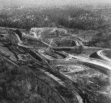
North of Bloor Street, it was built on a new alignment through the valley, requiring the removal of several hills, diversion of the Don River and the clearing of woodland.
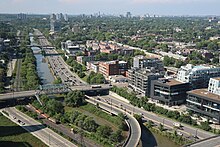
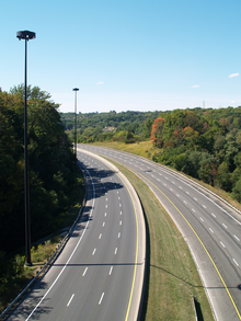
Beyond the southern, older section of the city, the valley widens and the parkway continues northwards through the parklands along the river to Don Mills Road.
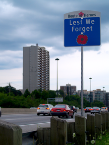
To travel east from the southbound lanes of the parkway, motorists must exit via an off-ramp that meets the Lake Shore Boulevard at a signalized intersection.
In this section, the elevation of the highway is close to the level of the river and is liable to flood after heavy rains, as occurred in June 2010, for example.
[10] The expressway rises from the floor of the valley and passes beneath the towering Prince Edward Viaduct bridge, which connects Bloor Street with Danforth Avenue and carries a subway line.
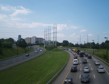
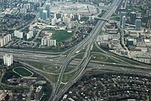
[21] The expressway crosses Taylor-Massey Creek and the East Don River, and climbs out of the valley, swinging northwards toward Eglinton Avenue.
[22] As it crosses Eglinton, the expressway passes a business park to the west and the Concorde Place commercial and condominium development to the east.
[24][25] Passing beneath Lawrence Avenue and back over the East Don River, the expressway begins climbing out of the valley once more.
RESCU operators monitor the cameras for emergency purposes; local radio and television media use the service for traffic reports.
Since completion, the parkway has not been changed significantly, other than adding one partial interchange at Wynford Drive and updating its infrastructure to current standards.
The Don River valley, formed during the last ice age, has played an important role in the development of Toronto from its beginning as the Town of York.
By 1900, the Don River south of today's Bloor Street was straightened into a channel for boating purposes, with roadways and industry built on both banks.
[41] The forests of the Don valley had been where Canadian naturalist Ernest Thompson Seton spent much of his youth in the 1870s studying animal life.
Unlike today's parkway, this road would have curved northwest near the Don Valley Brick Works and connected to Mount Pleasant at Davisville.
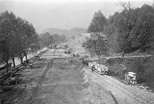
[48] The City started the first section of this route from Eastern Avenue south to Keating Street in 1949,[49] but had to suspend work in 1951 due to a lack of steel.
[51] The MTRCA began expropriating privately owned land in the valley for flood control, often creating or conserving open space uses.
South of Bloor Street, Metro agreed to replace any recreation facilities lost in Riverdale Park due to the parkway construction.
[55][71] Sugar Loaf Hill, shaped like a cone, which stood alone in the shadow of the Prince Edward Viaduct where Bayview Avenue passes today, was removed completely.
Metro relocated 1.2 km (0.75 mi) of CNR and CPR railway tracks in the section from Bloor Street to Chester Hill Road to make way for the parkway.
Royal Drive, which was a two-way road that connected with Bloor Street between Broadview Avenue and the Viaduct was re-purposed into a one-way north-bound on-ramp.
[81] In 1965, Metro Toronto Chief Coroner Morton Shulman released a report criticizing the lack of safety in the design of the parkway.
[83] The boxes, attached to street lighting on the right shoulder, provided a direct line for help from the Ontario Motor League, now part of the Canadian Automobile Association (CAA).
[86] [87] The Sheppard Avenue interchange with the parkway was originally a Parclo AB2, plus Fairview Mall Drive at the time ran only east-west directly north of the shopping centre and also had its own on/off-ramps from the southbound lanes of Highway 404.
To avoid delaying trains on the vital freight line, a prefabricated concrete arch was jacked into the embankment, 2 feet (0.61 m) at a time, over 12 days.
[88] From 1986 to 1988, the City studied traffic congestion in the 'Don Valley Corridor', an area from Leslie Street east to Victoria Park Avenue.
[92] In 2001, Toronto City Councillor Paul Sutherland proposed to add two toll lanes in each direction along the parkway, from Highway 401 to Eglinton Avenue.
[95] A second proposal, to allow GO Transit buses to use the left shoulder to pass slow traffic was approved in June 2010 by Toronto City Council.
[102] During the 2010 municipal election, mayoral candidate Sarah Thomson proposed a road toll for the Gardiner Expressway and Don Valley Parkway, drawing comments from critics and supporters across the city.
Waterfront Toronto is conducting an environmental assessment to evaluate replacing, modifying or removing the Gardiner Expressway east of Jarvis Street.
[8] A third project, the "Don River Valley Park" to link all of the open space from the Toronto Brick Works south to the harbour, has proposed changes that will impact the highway.