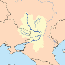
Donets
It gives its name to the Donets Basin, known commonly as the Donbas, an important coal-mining and industrial region in Ukraine.
[1][2] Scytho-Sarmatians inhabited the areas to the north of the Black Sea from 1100 BC into the early medieval times.
[4] The Slavic name of Seversky Donets derived from the fact that the river originates from the land of Severians.
[8][9][10] The Donets originates on the Central Russian Upland, near Podolkhi village, Prokhorovka area, north of Belgorod,[11] at an elevation of 200 m (660 ft) above sea level.
The spring flood lasts about two months, from February to April[15] – during this period the water level rises by 3 to 8 m (9.8 to 26.2 ft).
Excessive flooding is rare due to numerous artificial water reservoirs constructed along the river.
Near the Russian city of Donetsk (Rostov oblast), the river crosses the Donets Ridge and flows in a narrow valley with steep and rocky slopes.
At the end of the 19th - beginning of the 20th centuries, a number of attempts were made to revive shipping, in particular, for the sake of the possibility of water transportation of minerals in the Donbass.
In 1903-1904, he conducted a detailed study of the channel of the Seversky Donets and proposed a project to restore the navigation of the Seversky Donets to the city of Belgorod, which involves the construction of a large number of locks[20][21] were interrupted by World War I, Russian Civil War and lack of funds.
The river played a crucial role for its ancient settlers as a source of water and food, means of transportation and trade route.
Many of the related tribals had nomadic lifestyle characteristic of Kipchak people, Golden Horde and later of Cossacks.
The many Cossacks became later assimilated into the strengthening Russian Empire, which had rebuilt and reinforced the fortress of Belgorod and cities of Kyiv, Izium, Luhansk, Chuhuiv and others in order keep defensive lines against the raids of nomads from the south-east.
[25] Industrialization in the 20th century shifted interests to mineral exploitation in Donbas, with water-hungry plants concentrated mostly in Kyiv, Luhansk and Donetsk.
[26] Already by the 1930s, Kharkiv, Donetsk and Luhansk were lacking water forcing the authorities to gradually create a network of canals and reservoirs.
To supply water to southern Donbas and Donetsk, the 130-km long Donets-Donbas channel was built around 1958 starting near Raigorodok city,[15] and in compensation, the Dnieper-Donbas channel was created to supply water from Dnieper River to the upstream of the Donets via the Bereka River.
The density of plants and thus the contamination increase downstream in Donetsk and Luhansk areas, especially around Lysychansk and Sievierodonetsk, about 400 km from the mouth.
Some tributaries of the Donets, such as Kozenyi Butt, Bakhmut and Lugan are so polluted that consuming fish caught there is dangerous.
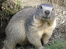
[28] Back in the 1960s–1970s, especially near Oskil River, it was not unusual to meet bobak marmot, Eurasian deer, wild boar and Russian desman.
The disappeared species include steppe eagle, tirkusha, sociable lapwing, bustard, black and winged lark.
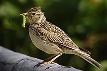
[45] The creation of artificial forest belts (windbreaks) in the basin in the 1960s brought insectivorous birds new to this area, such as Streptopelia, European magpie and shrikes.
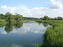
[28] The Donets is regarded as one of the most scenic rivers of East European Plain and contains many hiking and biking routes along its banks.