Sea of Azov
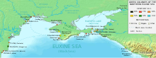
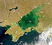
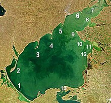
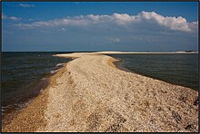
The sea is largely affected by the inflow of the Don, Kuban, and other rivers, which bring sand, silt, and shells, which in turn form numerous bays, limans, and narrow spits.
In 1997, William Ryan and Walter Pitman of Columbia University published a theory that a massive flood through the Bosporus occurred in ancient times.
[21] The Maeotian marshes around the mouth of the Tanais River (the present-day Don) were famous in antiquity, as they served as an important check on the migration of nomadic people from the Eurasian steppelands.
[22] Misled by its strong currents,[10] ancient geographers had only a vague idea of the extent of the sea, whose fresh water caused them to typically label it a "swamp" or a "lake".
[10] Polybius (2nd century BC) confidently expected that the strait to the Sea of Azov would close in the near future, due to ongoing deposition of sediments from rivers.
[23] In the 1st century, Strabo reckoned the distance from the Cimmerian Bosporus (the Strait of Kerch) to the mouth of the Tanais at 2200 stadia, a roughly correct figure,[b] but did not know that its width continuously narrows.
Its later history is uncertain but probably the Huns, after defeating the Alans people who had settled in the region from central Asia, overran it in the late 4th century.
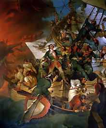
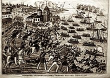
[25] The Sea of Azov was frequently the scene of military conflicts between Russia, pursuing naval expansion to the south, and the major power in the region, Turkey.
[26] The second campaign involved both ground forces and the Azov fleet, which was built in Moscow Oblast, Voronezh, Bryansk and other regions between winter 1695 and spring 1696.
After intensive bombardment of the fortress from land and sea, on 17 July the Russian army broke the defense lines and occupied parts of the wall.
[29] In December 2003, Ukraine and the Russian Federation agreed in a treaty to treat the sea and the Kerch Strait as shared internal waters.
The military posturing was exacerbated following the construction of the Crimean Bridge, which is too low to allow passage of Panamax ships into Ukraine's port.
[32] Late that September, two Ukrainian vessels departed from the Black Sea port Odesa, passed under the Crimean Bridge, and arrived in Mariupol.
[33] Tensions increased further after the Kerch Strait incident in November 2018, when Russia seized three Ukrainian Navy vessels attempting to enter the Sea of Azov.
[34] Control of the western shore of the Sea is vital to the economy of Ukraine but it is also of immense strategic importance to Russia, as a land route to Crimea as well as it is for passage by Russian marine traffic.
[36] The Russians seized three Ukrainian military vessel as the boats were trying to cross the strait, and captured 24 sailors who were finally released after months of negotiations.
[37][38] By May, with the end of the siege of Mariupol, Russia fully captured the city and blocked off Ukraine's access to the sea by controlling the entire north Pryazovia.
[42] The main rivers flowing into it are the Don and Kuban; they ensure that the waters of the sea have comparatively low salinity and are almost fresh in places, and also bring in huge volumes of silt and sand.
It is connected to the Black Sea by the Strait of Kerch, which at its narrowest has a width of 4 kilometres (2.5 mi) and a maximum depth of 15 metres (49 ft).
The occurrence of the anoxic layer is attributed to seasonal eutrophication events associated with increased sedimentary input from the Don and Kuban Rivers.
The sand, silt and shells[verification needed] they bring are deposited in the areas of reduced flow, that is the sides of the bays, forming narrow sandbanks called spits.
In autumn and winter, the weather is affected by the Siberian Anticyclone which brings cold and dry air from Siberia with winds of 4–7 m/s, sometimes up to 15 m/s.
[47] In the Kerch Strait, the flow is normally toward the Black Sea due to the predominance of northern winds and the water inflow from the rivers; its average speed is 10–20 cm/s, reaching 30–40 cm in the narrowest parts.
However, diversity and numbers have been reduced by artificial reduction of river flow (construction of dams), over-fishing and water-intense large-scale cultivation of cotton, causing increasing levels of pollution.
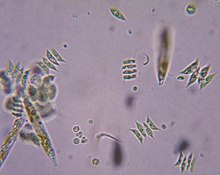
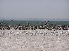
[62] Regarding zooplankton, the fresh waters of the Tanganrog Bay are inhabited by cladocera, copepoda and rotifers, such as Brachionus plicatilis, Keratella curdata and Asplanchna.
Western part of the sea, which is more saline, hosts three forms of Acartia clausi, as well as Centropages ponticus, meroplankton and larvae of gastropoda, bivalvia and polychaete.
From 1956, Rapana venosa is observed in the Sea of Azov, but it could not adjust to low salinity and therefore is limited to the neighborhood of the Kerch Strait.
The first modern ironworks in Imperial Russia were located upstream on the Kalmius River at Donetsk, originally named Hughesovka (Russian: Юзовка).
The ships were the Russian bulk carriers Volnogorsk; Nakhichevan; and Kovel, and the Georgian Haji Izmail with a Turkish crew.
[43] The irrigation system of the Taman Peninsula, supplied by the extended delta of the Kuban River, is favorable for agriculture and the region is famous for its vines.