Doom Bar
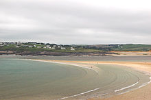
The Doom Bar (previously known as Dunbar sands, Dune-bar, and similar names) is a sandbar at the mouth of the estuary of the River Camel, where it meets the Atlantic Ocean on the north coast of Cornwall, England.
The estuary mouth, exposed to the Atlantic Ocean, is a highly dynamic environment, and the sands have been prone to dramatic shifts during storms.
According to tradition, the Doom Bar formed in the reign of Henry VIII, damaging the prosperity of the port of Padstow a mile up the estuary.
Many ships were wrecked on the Doom Bar, despite the installation of mooring rings and capstans on the cliffs and quarrying away part of Stepper Point to improve the wind.
In the early twentieth century, the main channel moved away from the cliffs, and continued dredging has made it much safer for boats, but deaths have occurred on the bar as recently as May 2020.
[2] This inflow is aided by wave and tidal processes, but the exact patterns of sediment transport within the estuary are complex and are not fully understood.
[4] All three are of similar composition; a large proportion of their sediment is derived from marine mollusc shells,[5] and as a consequence, it includes a high level of calcium carbonate, measured in 1982 at 62 per cent.
[7] High calcium carbonate levels combined with natural sea salt made the sand valuable to farmers as an alkaline fertiliser when mixed with manure.
[13] Exposed as they are to the Atlantic Ocean, the sands of the area have always been prone to sudden shifts: several houses were said to have been buried one night during a powerful storm.
[14] According to tradition one such shift led to the formation of the Doom Bar during the reign of Henry VIII (1509–1547), causing a decline in the prosperity of Padstow.
[15] Today, the sandbank covers approximately 0.4 square miles (1.0 km2), linking the beaches near Harbour Cove by sand flats, although the actual size and shape vary.
When sails were the main source of power, ships coming round Stepper Point would lose the wind, causing loss of steerage, leaving them to drift away from the channel.
The report recommended an initial expenditure of £20,000 to cut down the outer part of Stepper Point,[30] which, in conjunction with the capstans, bollards and mooring rings, would significantly reduce the risk to shipping.
[37] Despite the safer eastern channel and improvements in maritime technology, the Royal National Lifeboat Institution still deals with incidents at the Doom Bar.
The Whiting was originally a cargo ship named Arrow, which travelled from the United States to France; she was captured by the Royal Navy on 8 May 1812 and renamed.
[44] In May 2010 a marine research and exploration group, ProMare, and the Nautical Archaeology Society, with the help of Padstow Primary School, mounted a search for the ship.
[47] On New Year's Day 1895, she set sail from Newport in South Wales with a cargo of coal for Brazil, but foundered near Lundy Island, losing parts of her mast.
[51] Attempts by three tugs from Cardiff to remove the wreck were unsuccessful, but the next spring tide carried the midsection up the estuary onto Town Bar, opposite Padstow, where it was a hazard to shipping.
[54] "[The mermaid legend] is doubtless a myth, but it is a fact that a wailing cry is sometimes heard on the Doombar after a fearful gale and loss of life on that fateful bar, like a woman bewailing the dead."
[55] Rosamund Watson's "Ballad of Pentyre Town"[62] uses the sandbank for imagery to elicit feelings of melancholy when talking of giving up everything for love.
[63] A Victorian poem by Alice E. Gillington, "The Doom-Bar", relates the story of a girl who gave an engraved ring to the man she loved before he sailed away across the Doom Bar, breaking her heart.
A series of mishaps, blamed on the legendary wrecker Cruel Coppinger, culminating in a fire at Baltimore, caused the play to be considered cursed by America's actors' unions and its members were banned from appearing in it.