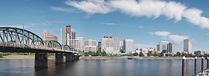
Downtown Portland, Oregon
The downtown neighborhood extends west from the Willamette to Interstate 405 and south from Burnside Street to just south of the Portland State University campus (also bounded by I-405), except for a part of northeastern portion north of SW Harvey Milk Street and east of SW 3rd Ave that belongs to the Old Town Chinatown neighborhood.
[4] New suburban shopping malls in the neighboring cities of Beaverton, Tigard, and Gresham competed with downtown for people and money.
Unlike many downtown revitalization efforts around the United States at this time, Portland's plan did not call for widespread demolition and reconstruction.
Moses charted a highway loop around the city's central freeways, which would become Interstate 405 as it links with I-5 south of downtown.
[5] Additionally the creation of a downtown transit mall in 1977, a new waterfront park in 1978 (later named after Governor Tom McCall) in place of a freeway, the creation of the Pioneer Courthouse Square in 1984, the opening of the Portland–Gresham light rail line in 1986, and the opening of Pioneer Place mall in 1990 successfully drew or retained businesses and lured customers.
[8][9][10] In 2020 and 2021, during the COVID-19 pandemic, Downtown Portland faced an increase in homeless camps and a reduction in office workers due to remote work.
During and after the Black Lives Matter protests, there was an increase in graffiti, property damage, and windows being boarded up.