Downtown Winnipeg
The City of Winnipeg's official downtown boundaries are: the Canadian Pacific Railway mainline on the north, Gomez Street and the Red River on the east, and the Assiniboine River on the south; the western boundaries of downtown are irregular, following along a number of different streets, back lanes, and across properties.
[3] Neighbourhoods in the downtown area include the Exchange District, Central Park, The Forks, and Chinatown.
The Waterfront District is a newly emerging mixed-use development located in the northeast corner of downtown Winnipeg.
The district runs along the west bank of the Red River along Waterfront Drive and features Stephen Juba Park.
Seventy per cent of all refugees coming to Winnipeg live downtown, in and around the Central Park area.
[13] The west side of the Exchange is home to Cinematheque, a small movie theatre located in the Artspace building on Albert Street.
Renovations to Old Market Square completed in 2012 added "The Cube", a $1.5 million stage, with a skin made up of 20,000 aluminum links.
[18] The most common transportation method of the people in South Portage is walking, with 31.8%, more than 6.5 times higher than the overall 4.9% for Winnipeg.
[19] The Forks is a 99-acre (40 ha) national historic, recreational, cultural, and entertainment area site in downtown Winnipeg, deriving its name from being located where the Assiniboine and Red Rivers meet.
The Forks was designated a National Historic Site of Canada in 1974 due to its status as a cultural landscape that had borne witness to six thousand years of human activity.
[21] The most common transportation method of the people in South Portage is walking, with 42.4%, more than five times higher than the overall 4.9% for Winnipeg.
[22] The area also has the Winnipeg Convention Centre with 160,000 sq ft (15,000 m2) of meeting, exhibition and banquet space.
[23] Lakeview Square, the largest mixed-use development downtown in the 1970s, was constructed at the same time as the Convention Centre and completed in 1974.
Opened in 2004, the Bell MTS Place is located just south of Portage Avenue and is home to the Winnipeg Jets.
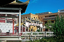
[25] Winnipeg's Chinatown covers 0.1 square kilometres (0.039 sq mi) northwest of City Hall and is home to about 600 people, of whom 90% are in the Chinese visible minority group.
Originally a toll bridge, it carried Winnipeg's first horse-drawn streetcars between downtown and River Avenue in the early 1880s.
The first version, called the Broadway Bridge, was not engineered correctly and fell into the Red River four days after opening due to ice jams colliding with it.