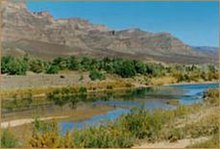
Draa River
The Draa (Berber languages: Asif en Dra, ⴰⵙⵉⴼ ⴻⵏ ⴷⵔⴰ, Moroccan Arabic: واد درعة, romanized: wad dərʿa; also spelled Dra or Drâa, in older sources mostly Darha or Dara, Latin: Darat) is Morocco's longest river, at 1,100 kilometres (680 mi).
In the first half of the 20th century, the lowest course of the Draa marked the boundary between the French protectorate of Morocco and the area under Spanish rule.
[4] Human occupation in the Draa valley and adjacent mountains dates at least to the Lower Paleolithic, as attested by Oldowan and Acheulean tools found near Tamegroute.
During the reign of the Wattasid Abu al-Abbas Ahmad ibn Muhammad, Askia Ishaq I of the Songhai Empire sent Tuareg raiders into the Draa valley to avenge a diplomatic insult where Morocco had demanded the cession of the valuable Taghaza salt mine.
The Draa has attracted the attention of a number of notable explorers including Frenchman Charles de Foucauld who travelled throughout Morocco disguised as a Jewish merchant in the 1800s, and Jeffrey Tayler who wrote a book about his experiences.