Wicklow Mountains
The Wicklow Mountains (Irish: Sléibhte Chill Mhantáin,[1] archaic: Cualu) form the largest continuous upland area in Ireland.
They were pushed up during the Caledonian orogeny at the start of the Devonian period and form part of the Leinster Chain, the largest continuous area of granite in Ireland and Britain.
The mountains owe much of their present topography to the effects of the last ice age, which deepened the glens and created corrie and ribbon lakes.
The Wicklow Mountains experience a temperate oceanic climate with mild, damp summers and cool, wet winters.
The mountains have been inhabited since Neolithic times and a number of typical monuments, in particular a series of passage tombs, survive to the present day.
Following the Norman invasion in the 12th century, the Wicklow Mountains became a stronghold and hiding place for Irish clans opposed to English rule.
[3] During the medieval period, prior to the establishment of County Wicklow, the English administration in Dublin referred to the region as the Leinster Mountains.
[15] These metamorphosed from sandstone deposited in the deep waters of the primeval Iapetus Ocean during the Cambrian period (542–488 million years ago).
[16] Layers of sediment continued to form slates and shales along the ocean floor mixed with volcanic rock pushed up as Iapetus began to shrink by the process of subduction during the Ordovician period (488–443 million years ago).
[24] The last major geological event to shape the Wicklow Mountains was the Quaternary glaciation during the Pleistocene epoch (2.6 million to 11,700 years ago).
[26] As the ice melted, small glaciers were left in corries where moraines now dam lakes such as at Loughs Bray and Nahanagan.
[39] In 1720, Trinity College Dublin accounts show that one John Bawnan was paid £11-10s-7d for "Blessington Stones delivered for work on the new kitchen" there.
[40] From 1824, the quarries at Ballyknockan provided material for buildings such as the Bank of Ireland on College Green in Dublin, Dún Laoghaire lighthouse and Liverpool Cathedral until they closed in the late 20th century.
Since the thin blanket bog peats cannot hold great quantities of water, many of these rivers exhibit a flashy hydrography, filling rapidly after heavy rain.
[52] Each of the main branches of the River Avoca—the Avonmore, the Avonbeg and the Aughrim rivers—have their origins in smaller tributaries, many of which rise in the Wicklow Mountains.
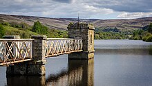
[53] The River Dodder feeds the two Bohernabreena reservoirs in the northern foothills of the Wicklow Mountains at Glenasmole in County Dublin, which were constructed between 1883 and 1887 to supply water to the townland of Rathmines.
[57] Water is pumped up from Lough Nanahangan, a natural corrie lake, into an artificial reservoir on Tomaneena mountain and released at times of peak electricity demand.
[58][59] In common with the rest of Ireland, the Wicklow Mountains experience a temperate oceanic climate with mild, damp summers and cool, wet winters.
The mountain blanket bogs formed around 4,000 years ago as a result of a combination of climate change and human activity.
[63] A change in the climate to wetter and milder weather left the ground waterlogged and leached nutrients from the soil, leading to the formation of peat.
[67] Due to drainage of water from the bogs as a result of human activity, most of Wicklow's peat has dried out too much for Sphagnum mosses to grow and moorland and heath vegetation has taken over.
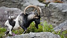
[74] The Irish elk is an extinct species of deer that lived in the Wicklow Mountains c. 11,000 years ago, remains of which were discovered in great quantities in Ballybetagh Bog near Glencullen.
[84] Passage tombs, from the Neolithic period, are the earliest and most prominent feature of prehistoric Irish civilisation in the Wicklow Mountains.
[92] Monasteries were often attacked, especially at times of disease or famine, and Glendalough's wealth made it a frequent target for both local tribes and, later, Norse invaders.
[105] Although the main rebellion was quickly defeated, Irish rebels once again used the Wicklow Mountains as a hiding place and stronghold to attack the English for many years afterwards.
[106] Among their number was Michael Dwyer, a native of the Wicklow Mountains, born in the townland of Camara in the Glen of Imaal, and General Joseph Holt.
[107] Determined to prevent any future rebel activity, a military road through the mountains, similar to those built in the Scottish Highlands to quell the Jacobite risings, was proposed by the British government to enable troops to be deployed quickly into the region.
[109] A series of army barracks and police stations were built along the route, although they were little used and soon fell into disrepair as the Wicklow Mountains soon ceased to be a centre of rebel activity after the road was completed.
[110] Following the Great Famine, the census of 1891 showed that the population of County Wicklow had declined to 62,136 with the proportionate fall in the uplands regions even greater as the populace deserted the marginal lands.
[112] The tourism potential of the Military Road was spotted soon after its completion and G. N. Wright's Tours in Ireland (1822) is one of the earliest guides to the sights along the route.