Ducie Island
The objective of the expedition was to take soldiers, friars and provisions to establish a colony in the Santa Cruz Islands.
On the same day, he also sighted two more islands, one that he named San Juan Bautista ("St John the Baptist"), and the other La Encarnación ("the Incarnation").
[5] The confusion was later compounded when a chart produced by Admiral José de Espinosa marked Ducie as La Encarnación, rather than as Luna Puesta.
[6] Edwards named it in honour of Francis Reynolds-Moreton, 3rd Baron Ducie, under whom he had served earlier in his career.
[7] HMS Pandora turned northwards from Ducie and, because of this change of course, Edwards did not sight the other islands of the group.
If HMS Pandora had maintained its course, it would eventually have reached Pitcairn Island and found the Bounty mutineers.
[8] The crew of the whaleship Essex, which a whale had attacked and sunk in November 1820, mistakenly believed that they had reached Ducie after a month at sea in two whaleboats.
[9] Captain Thomas Raine of Surrey, who was searching for the survivors of Essex, in 1820 made the first recorded landing on Ducie.
[5] Frederick William Beechey, who arrived in HMS Blossom during November 1825, wrote the first comprehensive description of the island.
[12] On 5 June 1881, the mail ship Acadia ran aground on the island while returning from San Francisco, Peru after unloading its cargo.
On the way to Queenstown or Falmouth for new orders, Master Stephen George calculated a route passing 15 to 20 miles (24 to 32 km) to the east of Ducie.
He was assisted there by the local inhabitants and returned aboard the Edward O'Brien, an American boat, to rescue the rest of the crew.
[26] On 19 December 1902, commissioned by R. T. Simmons, the British Consul in Tahiti, Captain G. F. Jones and a group of Pitcairners visited the nearby islands and annexed them to the United Kingdom.
[5] On 4 August 1937, Captain J. W. Rivers-Carnac, commander of HMS Leander, reaffirmed British sovereignty over Ducie by hoisting the Union Flag and placing boards proclaiming the island to be the property of King George VI.
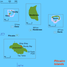
[31] Ducie lies 290 miles (470 km) east of Pitcairn Island and is claimed by some to be the southernmost atoll in the world at 24°41' S latitude.
[32] However, Elizabeth Reef in the Tasman Sea is at 29°57 S latitude, so the assertion on behalf of Ducie Island is doubtful.
Ducie Island's land area is 170 acres (69 ha) and its maximum elevation, occurring on the Westward islet, is 15 feet (4.6 m).
[32] The islets were named by Harald Rehder and John Randall, who visited the atoll during an expedition by the Smithsonian Institution in 1975.
[37] The atoll has a central lagoon, accessible by boat only by way of a channel 100 yards (91 m) wide located in the southwest, between Pandora and Westward Islets.
In the lagoon, sparse, living coral can be found;[32] the dominant species is Montipora bilaminata (family Acroporidae).
[22] The island has been identified by BirdLife International as an Important Bird Area (IBA), principally for its colonies of Murphy's, herald, and Kermadec petrels, and Christmas shearwaters.
[58] The 1991–92 Pitcairn Islands Scientific Expedition found specimens of both the mourning gecko and the white-bellied skink.