Early Streets of Brisbane
[1] In May 1825 Lieutenant Henry Miller moved the Moreton Bay penal colony from the Redcliffe Peninsula to the northern bank of the Brisbane River.
The settlers faced hardship and privation and the paucity of resources combined with thick sub-tropical vegetation made settlement difficult.
[1] The site of Brisbane Town was an ongoing issue, with Commandant Patrick Logan proposing that the settlement be moved to Stradbroke Island.
Logan continued to seek alternative sites, establishing a number of outstations including Eagle Farm and Oxley Creek.
[1][2]: 48 The Moreton Bay Penal Settlement during its 15 years of operation consisted of a range of buildings including barracks for convicts and troops, officers' quarters, dwellings for the Commandant, chaplain, Commissariat officer, surgeon, Commandant's clerk and engineer, a military and convict hospital, the Commissariat Store, and various stores, barns and sheds.
[1] The Commandant's cottage was constructed in 1825 on the site of the old Queensland Government Printing Office building (now the Public Service Club between William and George Streets.
The first prisoner accommodation also consisted of slab huts, probably at the intersection of Queen and Albert Streets; stone barracks were constructed in 1829.
The main thoroughfare into the settlement was up the steep river bank following the present day alignment of Queen's Wharf Road.
[4]: illustration 59 Pedestrians were able to enter the settlement through the vacant land immediately northwest of the Commissariat Store, in what is today known as Miller Park.
The garden was under the charge of the Superintendent of Agriculture and produced a wide range of vegetables including cabbage, cauliflower, peas, beans, potatoes and pumpkins, as well as fruit trees and plants such as banana, pineapple, citrus, and apple.
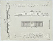
[1][4]: illustration 129 The new Commissariat Store, Brisbane was constructed in 1828 and 1829, on its site between present day William Street and Queens Wharf Road.
The two story utilitarian building was constructed of local porphyry and sandstone, with its ground and second floor doors opening towards the river and the wharf.
[1] One of the major thoroughfares of the settlement, taken by Allan Cunningham in his 1829 survey, ran along the rear of the Prisoners Barracks towards a pathway up to the windmill tower and to the Kangaroo Point Road.
[1] A plan of Brisbane Town drawn by draftsman H. W. Marriott on 24 March 1840 was forwarded to the New South Wales Surveyor-General by Surveyor Henry Wade on 26 April 1842.
[1] The Early Streets of Brisbane have the potential to contain archaeological artefacts that are an important source of information about Queensland's history.
Potential subsurface remains will demonstrate the establishment, evolution and pattern of settlement of early Brisbane as a penal colony.
The streets therefore are the least disturbed areas in the Brisbane Central Business District (CBD) with the most potential for the presence of the earliest remains of Queensland's European settlement.
The remains of buildings, features and other artefacts have the potential to provide insight into the material culture and life ways of the convicts, soldiers and administrators of the penal settlement.
This will contribute information to the collective understanding of convict sites around Australia and the place of Queensland in the system of forced migration and punishment of the 18th and 19th centuries.
[1] Given the accumulation of material from the initial European settlement of Brisbane to the present day, there is also the potential for archaeological remains from subsequent periods to be recovered.
[14][15] The level of disturbance has been designated as "Intact" given the minor subsurface works undertaken and the tendency for accumulation of deposits when constructing or renewing road surfaces.
This combination of being designated "exceedingly rare" and "intact" leads to the categorisation of the Early Streets of Brisbane as having "Exceptional Archaeological Research Potential".