EarthScope
Organizations associated with the project included UNAVCO, the Incorporated Research Institutions for Seismology (IRIS), Stanford University, the United States Geological Survey (USGS) and National Aeronautics and Space Administration (NASA).
The various EarthScope components provided integrated and highly accessible data on geochronology and thermochronology, petrology and geochemistry, structure and tectonics, surficial processes and geomorphology, geodynamic modeling, rock physics, and hydrogeology.
USArray, managed by IRIS, was a 15-year program to place a dense network of permanent and portable seismographs across the continental United States.
The goal of USArray was primarily to gain a better understanding of the structure and evolution of the continental crust, lithosphere, and mantle underneath North America.
EarthScope added and upgraded 39 stations to the already existing Advanced National Seismic System, which was part of the Reference Network.
These instruments were complemented by InSAR (interferometric synthetic aperture radar) and LiDAR (light detection and ranging) imagery and geochronology acquired as part of the GeoEarthScope initiative.
Seismic tomography helps constrain mantle velocity structure and aids in the understanding of chemical and geodynamic processes that are at work.
The range and resolution of this technique allowed investigation into the suite of problems that are of concern in the North American mantle lithosphere, including the nature of the major tectonic features.
This method gives evidence for differences in thickness and the velocity anomaly of the mantle lithosphere between the stable center of the continent and the more active western North America.
The main function of the Advanced National Seismic System (ANSS) and USArray, was to provide high quality data for earthquake monitoring, source studies and Earth structure research.
Sources of seismic noise within the Earth are caused by any of the following: the actions of human beings at or near the surface of the Earth, objects moved by wind with the movement being transferred to the ground, running water (river flow), surf, volcanic activity, or long period tilt due to thermal instabilities from poor station design.
A new approach to seismic noise studies was introduced with the EarthScope project, in that there were no attempts to screen the continuous waveforms to eliminate body and surface waves from the naturally occurring earthquakes.
Waveform fit and amplitude-phase match figures were provided to allow users to evaluate moment tensor quality.
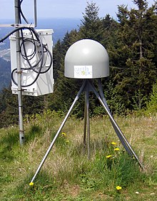
Global Positioning System (GPS) equipment and techniques provide a unique opportunity for earth scientists to study regional and local tectonic plate motions and conduct natural hazards monitoring.
The daily GPS measurements from ~1500 stations along the Pacific/North American plate boundary provided millimeter-scale accuracy and could be used monitor the displacements of the earths crust.
The goal was to provide models of time-dependent strain associated with a number of recent earthquakes and other geologic events as constrained by GPS data.
With the use of InSAR (Interferometric Synthetic Aperture Radar), a remote-sensing technique, and PBO (Plate Boundary Observatory), a fixed array of GPS receivers and strainmeters, the EarthScope project provided spatially continuous strain measurements over wide geographic areas with decimeter to centimeter resolution.
A completed global strain rate map provided a large amount of information which will contribute to the understanding of continental dynamics and for the quantification of seismic hazards.
A few questions EarthScope addressed include: Crustal strain and deformation is the change in shape and volume of continental and oceanic crust caused by stress applied to rock through tectonic forces.
A few questions EarthScope addressed include: Through the use of seismology, scientists were be able to collect and evaluate data from the deepest parts of our planet, from the continental lithosphere down to the core.
Seismic data gave scientists more understanding and insight into the lower mantle and the Earth's core, as well as activity at the core-mantle boundary.
The program reached out to scientific educators and students as well as industry professionals (engineers, land/resource managers, technical application/data users), partners of the project (UNAVCO, IRIS, USGS, NASA, etc.
"To use EarthScope data, products, and results to create a measurable and lasting change on the way that Earth science is taught and perceived in the United States."
EarthScope promised to produce a large amount of geological and geophysical data to the door for numerous research opportunities in the scientific community.
Future uses of the data that it produced might include hydrocarbon exploration, aquifer boundary establishment, remote sensing technique development, and earthquake risk assessment.
Researchers analyzing the data left us with a greater scientific understanding of geologic resources in the Great Basin and of the evolution of the plate boundary on the North American west coast.
The science produced by EarthScope and the researchers using its data products help guide lawmakers in environmental policy, hazard identification, and ultimately, federal funding of more large-scale projects like this one.
Representatives in Washington D.C. and the state capitals require guidance from authoritative science in drafting the soundest environmental laws for our country.
In fact, the Federal Emergency Management Agency (FEMA) has awarded the Arizona Geological Survey and its partner universities funding to adopt and maintain eight Transportable Array stations.
For EarthScope to live up to its potential in the Earth sciences, the connections between the research and the education and outreach communities must continue to be cultivated.