Earth ellipsoid
It is a spheroid (an ellipsoid of revolution) whose minor axis (shorter diameter), which connects the geographical North Pole and South Pole, is approximately aligned with the Earth's axis of rotation.
Many methods exist for determination of the axes of an Earth ellipsoid, ranging from meridian arcs up to modern satellite geodesy or the analysis and interconnection of continental geodetic networks.
It refers to a theoretical coherence between the geographic latitude and the meridional curvature of the geoid.
The latter is close to the mean sea level, and therefore an ideal Earth ellipsoid has the same volume as the geoid.
Another reason is a judicial one: the coordinates of millions of boundary stones should remain fixed for a long period.
However, for international networks, GPS positioning, or astronautics, these regional reasons are less relevant.
In geodesy, a reference ellipsoid is a mathematically defined surface that approximates the geoid, which is the truer, imperfect figure of the Earth, or other planetary body, as opposed to a perfect, smooth, and unaltered sphere, which factors in the undulations of the bodies' gravity due to variations in the composition and density of the interior, as well as the subsequent flattening caused by the centrifugal force from the rotation of these massive objects (for planetary bodies that do rotate).
Because of their relative simplicity, reference ellipsoids are used as a preferred surface on which geodetic network computations are performed and point coordinates such as latitude, longitude, and elevation are defined.
In 1687 Isaac Newton published the Principia in which he included a proof that a rotating self-gravitating fluid body in equilibrium takes the form of a flattened ("oblate") ellipsoid of revolution, generated by an ellipse rotated around its minor diameter; a shape which he termed an oblate spheroid.
[2][3] In geophysics, geodesy, and related areas, the word 'ellipsoid' is understood to mean 'oblate ellipsoid of revolution', and the older term 'oblate spheroid' is hardly used.
Starting in the late twentieth century, improved measurements of satellite orbits and star positions have provided extremely accurate determinations of the Earth's center of mass and of its axis of revolution; and those parameters have been adopted also for all modern reference ellipsoids.
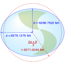
The ellipsoid WGS-84, widely used for mapping and satellite navigation has f close to 1/300 (more precisely, 1/298.257223563, by definition), corresponding to a difference of the major and minor semi-axes of approximately 21 km (13 miles) (more precisely, 21.3846857548205 km).
For comparison, Earth's Moon is even less elliptical, with a flattening of less than 1/825, while Jupiter is visibly oblate at about 1/15 and one of Saturn's triaxial moons, Telesto, is highly flattened, with f between 1/3 and 1/2 (meaning that the polar diameter is between 50% and 67% of the equatorial.
Two meridian arc measurements will allow the derivation of two parameters required to specify a reference ellipsoid.
Then, the flattening would readily follow from its definition: For two arc measurements each at arbitrary average latitudes
[6] Then discrepancies between empirical and theoretical values of the radius of curvature can be formed as
In practice, multiple arc measurements are used to determine the ellipsoid parameters by the method of least squares adjustment.
Regional-scale systematic effects observed in the radius of curvature measurements reflect the geoid undulation and the deflection of the vertical, as explored in astrogeodetic leveling.
Gravimetry is another technique for determining Earth's flattening, as per Clairaut's theorem.
The reference ellipsoid models listed below have had utility in geodetic work and many are still in use.
The older ellipsoids are named for the individual who derived them and the year of development is given.
In 1887 the English surveyor Colonel Alexander Ross Clarke CB FRS RE was awarded the Gold Medal of the Royal Society for his work in determining the figure of the Earth.
At the 1967 meeting of the IUGG held in Lucerne, Switzerland, the ellipsoid called GRS-67 (Geodetic Reference System 1967) in the listing was recommended for adoption.
It became a part of the GRS-67 which was approved and adopted at the 1971 meeting of the IUGG held in Moscow.
The GRS-80 (Geodetic Reference System 1980) as approved and adopted by the IUGG at its Canberra, Australia meeting of 1979 is based on the equatorial radius (semi-major axis of Earth ellipsoid)
seen between GRS-80 and WGS-84 results from an unintentional truncation in the latter's defining constants: while the WGS-84 was designed to adhere closely to the GRS-80, incidentally the WGS-84 derived flattening turned out to differ slightly from the GRS-80 flattening because the normalized second degree zonal harmonic gravitational coefficient, that was derived from the GRS-80 value for
Commonly an ellipsoidal model is part of a more encompassing geodetic datum.
For example, the older ED-50 (European Datum 1950) is based on the Hayford or International Ellipsoid.
WGS-84 is peculiar in that the same name is used for both the complete geodetic reference system and its component ellipsoidal model.