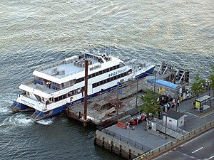
East 34th Street Ferry Landing
[8][9] The ferry dock in Hunters Point was located adjacent to the LIRR's Long Island City station, which became the railroad's western terminus in 1861, and was also situated near the beginning of Jackson Avenue, a 6-mile-long (9.7 km) road leading to Flushing that opened in 1860.
[13] Connecting mass transit service was provided by the 34th Street Ferry elevated station which was located east of First Avenue and operated from 1880 to 1930.
[14] In addition to carrying daily commuters to and from Long Island, the ferry was also heavily used by passengers destined to Belmont Park, Sheepshead Bay Race Track, the North Beach Amusement Park (located adjacent to Bowery Bay), and Calvary Cemetery, requiring the use of special guards to accommodate the crowds on race days, Sundays, and holidays.
[18] A ferry was not intended to be a permanent solution to the traffic problem, and plans had already been drawn up for a proposed vehicular tunnel connection between 38th Street in Manhattan and Long Island City.
[27] Beginning in the mid-1980s, proposals were made to provide ferry service along the East River corridor as an alternative form of public transportation.
[28][29] The feasibility of a new ferry service between Hunters Point and Manhattan was also studied as a means to improve access to the proposed Queens West redevelopment project along the Long Island City waterfront.
[49][50] Restoration of the traditional Hunters Point crossing was initiated by NY Waterway in October 1994 but was later abandoned in March 2001 due to a decline in ridership.
[59][60][61] Ferries from East 34th Street also provided service to the Water Taxi Beach in Long Island City that the company operated during the summer months.
[62] In the early 2000s, improvements at the East 34th Street landing were planned by the New York City Economic Development Corporation (NYCEDC) to support the development of a ferry corridor along the East River, providing an alternate mode of transportation for commuters as well as a public safety measure in light of the role played by ferry terminals for emergency evacuation following the September 11 attacks.
[4][67][68][69][70] A vehicular drop-off and pickup area for buses and taxis was constructed at the foot of East 34th Street that could be accessed from the service road below the FDR Drive viaduct.
The terminal upgrades also improved public access to the waterfront in the vicinity of the ferry landing, which forms part of the East River Greenway, with the installation of new pavement, benches, landscaping, lighting, and esplanade railing.
[2][65][71] Ken Smith Landscape Architects collaborated with Kennedy & Violich on the design of the ferry landing and upland esplanade; the firm originally intended to include riparian plantings (such as Spartina) that were protected from river currents by structured planters and irrigated by tidewater using windmills.
[74] After a request for bids, NYCEDC in 2011 awarded NY Waterway a three-year contract and a $3 million annual subsidy to operate ferry service on the East River including 34th Street.
[80] In the aftermath of infrastructure damage and service disruptions to the New York City Subway system in Queens and Brooklyn caused by Hurricane Sandy on October 29, 2012, Seastreak began running weekday ferry service between East 34th Street and Rockaway Park, Queens, with additional stops at Pier 11 and Brooklyn Army Terminal.
[92] New York Water Taxi operates a shuttle service for NYU Langone Health between 34th Street and the Brooklyn Army Terminal.
[96] The Lower East Side Ferry used to operate between Long Island City and Pier 11/Wall Street via eastern Manhattan year-round, but was then discontinued on May 18, 2020 due to low ridership.