Franconia
On the other hand, the inhabitants of the Hessian-speaking parts of Lower Franconia west of the Spessart (largest city: Aschaffenburg) do consider themselves Franconian, although not speaking the dialect.
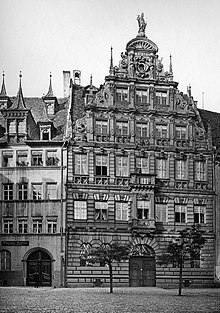
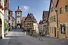
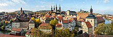
Other important Franconian cities are Würzburg, Bamberg, Bayreuth, Ansbach and Coburg in Bavaria, Suhl and Meiningen in Thuringia, and Schwäbisch Hall in Baden-Württemberg.
The Franconian lands lie principally in Bavaria, north and south of the sinuous River Main which, together with the left (southern) Regnitz tributary, including its Rednitz and Pegnitz headstreams, drains most of Franconia.
The Franconian lands include the present-day South Thuringian districts of Schmalkalden-Meiningen, Hildburghausen and Sonneberg, the historical Gau of Grabfeld, held by the House of Henneberg from the 11th century and later part of the Wettin duchy of Saxe-Meiningen.
The hills of the Franconian Jura in the south mark the border with the Upper Bavarian region (Altbayern), historical Swabia, and the Danube basin.
Further cities in Bavarian Franconia include Würzburg, Erlangen, Bayreuth, Bamberg, Aschaffenburg, Schweinfurt, Hof, Coburg, Ansbach and Schwabach.
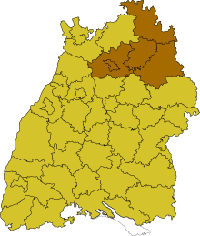
The major (East) Franconian towns in Baden-Württemberg are Schwäbisch Hall on the Kocher — the imperial city declared itself "Swabian" in 1442 — and Crailsheim on the Jagst river.
Franconia may be distinguished from the regions that surround it by its peculiar historical factors and its cultural and especially linguistic characteristics, but it is not a political entity with a fixed or tightly defined area.
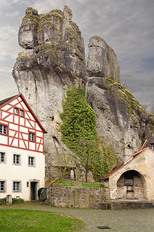
[19] Among the most picturesque geotopes in Bavaria, are the Franconian sites of Fossa Carolina, the Twelve Apostle Rocks (Zwölf-Apostel-Felsen), the Ehrenbürg, the cave ruins of Riesenburg and the lake of Frickenhäuser See.
These are rocks of pre-Permian vintage, which were folded during various stages of Variscan orogeny in the Late Palaeozoic - before about 380 to 300 million years ago - and, in places, were metamorphosed under high pressure and temperature or were crystallized by ascending magma in the Earth's crust.
[24] Rocks which were unchanged or only lightly metamorphosed, because they had been deformed at shallow crustal depths, include the Lower Carboniferous shale and greywacke of Franconian Forest.
The Fichtel mountains are also characterized by large granite bodies, called post-kinematic plutons which, in the late phase of Variscan orogeny, intruded into the metamorphic rocks.
[26] A substantially larger part of the shallow subsurface in Franconia comprises Mesozoic, unmetamorphosed, unfolded rocks of the South German Scarplands.
[33] There the deposits are somewhat younger (Upper Bunter Sandstone), and the corresponding stratigraphic interval is called the Franconian Chirotherium Beds (Fränkische Chirotherienschichten).
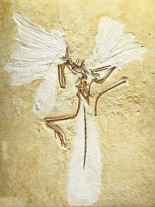
In addition to Archaeopteryx, in the very fine-grained, laminated lagoon limestones are the pterosaur Pterodactylus and various bony fishes as well as numerous extremely detailed examples of invertebrates e.g. feather stars and dragonflies.
[51] Fossil finds show that the region was already settled by primitive man, Homo erectus, in the middle Ice Age about 600,000 years ago.
Probably the oldest human remains in the Bavarian part of Franconia were found in the cave ruins of Hunas at Pommelsbrunn in the county of Nuremberg Land.
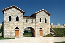
To protect it, the Romans built several forts like Biriciana at Weißenburg, but by the mid-third century, the border could no longer be maintained and by 250 A.D. the Alemanni occupied the areas up to the Danube.
[65] Franconia soon played an important role again for the monarchy at the time of Rudolf of Habsburg; the itineraries of his successors showing their preference for the Rhine-Main region.
[61] In the late Middle Ages and Early Modern Period, the Imperial Circle was severely affected by Kleinstaaterei, the patchwork of tiny states in this region of Germany.
[86] As a result, the Franconian Circle had the important task of preserving peace, preventing abuses and to repairing war damage and had a regulatory role in the region until the end of the Holy Roman Empire.
[90] In 1806, the Act of Confederation led to stronger ties between Bavaria, Württemberg, Baden and other areas with France, whereupon the Holy Roman Empire including the Franconian Circle fell apart.
[91] In the so-called Rittersturm of 1803, Bavaria, Württemberg and Baden seized the territories of the Imperial Knights and Franconian nobility, whose estates were often no bigger than a few parishes, even though the Reichsdeputationshauptschluss had not authorised this.
In order to merge the patchwork quilt of small states in Franconia and Swabia into a greater Bavaria, Maximilian Joseph Montgelas reformed the political structure.
[106] In the closing stages of the Second World War, at the end of March and April 1945, Franconian towns and cities were captured by formations of the US Army who advanced from the west after the failure of the Battle of the Bulge and Operation Nordwind.
In Lower and Upper Franconia, there was still the problem, however, of the zone along the Inner German Border which was a long way from the markets for its agricultural produce, and was affected by migration and relatively high unemployment,[113] which is why these areas received special support from federal and state governments.
[114] The Soviet occupying forces exacted a high level of reparations (especially the dismantling of industrial facilities) which made the initial economic conditions in East Germany very difficult.
[117] Since Die Wende, new markets have opened up for the Franconian region of Bavaria in the new (formerly East German) federal states and the Czech Republic, enabling the economy to recover.
[120][citation needed] The city of Fürth in Middle Franconia historically (before the Nazi era) had a large Jewish population; Henry Kissinger was born there.
Food typical for the region includes Bratwurst (especially the famous small Nuremberger Bratwurst), Schäuferla (roast pork shoulder), Sauerbraten, dumplings, potato salad (typically made with broth), fried carp, Grupfder (seasoned cheese spread), Presssack (a type of Head cheese: pressed or jellied pork trimmings, like tongue, cheeks, etc.).


Here: the vestry of Meiningen's municipal church in South Thuringia. The Franconian Rake may be seen on the left