Lomond Hills
The name Lomond Hills was first recorded Lomondys in 1315,[2] and may derive from a Pictish cognate of Welsh llumon, meaning "beacon",[2] an element found for example in the hill-name Pumlumon in Wales.
[2] Also suggested is derivation from Gaelic lom monadh, "bare hill",[2] perhaps adapted from an earlier Pictish name containing cognate elements.
Along the edges of the sandstone bed at the foot of the scarp slopes are several strikingly eroded outcrops, the most famous of which are the Bunnet Stane and John Knox's Pulpit,[6] so named because it is believed to be a spot where covenanters held conventicles in the 17th century.
There are also striking outcrops in the columnar jointing at the edge of the dolerite sill on Bishop Hill, most notably Carlin Maggie.
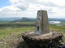
[7][8][9] The remains of Iron Age hill forts can be found around the summits of both East and West Lomond as well as at Maiden Castle, a grassy knoll that lies between the two.
There are six reservoirs in the Lomond Hills that were originally constructed to supply water to the rapidly growing mining towns of west Fife.
The Lomond Hills lie within the boundaries of Fife Regional Park, renamed the Lomond Hills Regional Park in 2003, and have their own ranger service who work principally with the landowners, estate managers and farmers on issues such as public access to help minimise the impact of recreational activities on their day-to-day business.
This has resulted in a considerable amount of footpath erosion, particularly on the steeper sections, that the ranger service and volunteer workers are taking measures to counteract.
Alternative routes exist from the Bunnet Stane, the village of Falkland and the car park at the masts, high on East Lomond.