Ebro
The Ebro (Spanish and Basque [ˈeβɾo] ⓘ; Catalan: Ebre, Western: [ˈeβɾe], Eastern: [ˈeβɾə]) is a river of the north and northeast of the Iberian Peninsula, in Spain.
The Ebro flows through many cities (Spanish: ciudades):[a] Reinosa in Cantabria; Frías and Miranda de Ebro in Castile and León; Haro, Logroño, Calahorra, and Alfaro in La Rioja; Tudela in Navarre; Alagón, Utebo, and Zaragoza in Aragon; and Flix, Móra d'Ebre, Benifallet, Tivenys, Xerta, Aldover, Tortosa, and Amposta in the province of Tarragona (Catalonia).
Flowing roughly eastwards it passes las conchas de Haro and begins forming a wider river valley among limestone rocks when it reaches La Rioja and Navarre.
Much of the total water volume of the Ebro comes from its northern tributaries, which drain about 2⁄3 of the southern slopes of the Pyrenees mountains, which run along the border with France.
[1] Downstream from Cantabria the climate in the Ebro basin – the valley being isolated from sea air masses by surrounding mountains – becomes Mediterranean/Atlantic influenced and continental.
Summers of the Ebro Valley most often mirror those of a semiarid climate; some of them see more breaks of storms or showers, yet others are more arid, bringing drought save where advanced irrigation is used.
Karst geological processes shaped the landscape of layers of soluble carbonate rock of extensive limestone bedrock formed in an ancient seabed.
There, larger tributaries flowing from the central Pyrenees and the Iberian System discharge large amounts of water, especially in spring during the thawing season of the mountain snow.
The mountain vegetation is mostly coniferous forests that are drought-adapted, and hardier trees in the oak genus (Quercus), typically less tolerant, in the wetter highlands.
The calcareous cliffs and high, rocky hills of the Serra de Cardó almost abut the river separating the Mediterranean coastal strip.
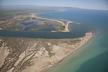
After passing the gorges, the Ebro bends again eastwards near Tortosa before discharging in a delta on the Mediterranean Sea close to Amposta in the province of Tarragona.
Designated a Ramsar site,[3] it has entirely grown on soils washed downriver—the historical rate of growth of the delta is demonstrated by the town of Amposta.
[2] The rounded form of the delta attests to the subsequent balance between sediment deposition by the Ebro and removal of this material by wave erosion.
[3][2] A network of canals and irrigation ditches dug by agricultural and conservation groups help to maintain the ecologic and economic resources of the delta.
In antiquity, the Ebro was used as the dividing line between Roman (north) and Carthaginian (south) expansions after the First Punic War (264–241 BC).
Academics and local government have criticised ecological impacts of: In past times numerous lagoons, endorheic saltwater ponds, and freshwater swamps and marshes were drained, dried or filled.
Due to dams and hydraulic canalization, the dynamics of the river have been altered and new scroll-bars, new oxbow lakes, and new abandoned meanders will not now be created.
The Ebro Delta Natural Park, covering 7,802 hectares (19,280 acres), was finalised in 1986 and is of international importance for 8 of its plant species and 69 of its vertebrate fauna.
The semiaquatic rodent Myocastor coypus is beginning to expand in some northwest tributaries of the head damaging crops and protected national parks in the Basque Country.
Fish caught in all lower reaches of the Ebro are high in mercury and the European Union prohibits their sale, notably the huge Wels catfish.