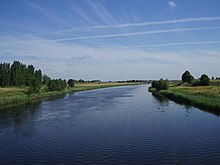
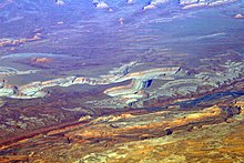
Meander
The result of this coupled erosion and sedimentation is the formation of a sinuous course as the channel migrates back and forth across the axis of a floodplain.
[1][3] The term derives from the winding river Menderes located in Asia-Minor and known to the Ancient Greeks as Μαίανδρος Maiandros (Latin: Maeander),[4][5] characterised by a very convoluted path along the lower reach.
As a result, even in Classical Greece (and in later Greek thought) the name of the river had become a common noun meaning anything convoluted and winding, such as decorative patterns or speech and ideas, as well as the geomorphological feature.
It flows through series of three graben in the Menderes Massif, but has a flood plain much wider than the meander zone in its lower reach.
[8] Meanders are a result of the interaction of water flowing through a curved channel with the underlying river bed.
This initiates helicoidal flow: Along the river bed, fluid roughly follows the curve of the channel but is also forced toward the inside bend; away from the river bed, fluid also roughly follows the curve of the channel but is forced, to some extent, from the inside to the outside bend.
Ideal waveforms, such as a sine wave, are one line thick, but in the case of a stream the width must be taken into consideration.
The bankfull width is the distance across the bed at an average cross-section at the full-stream level, typically estimated by the line of lowest vegetation.
As a waveform the meandering stream follows the down-valley axis, a straight line fitted to the curve such that the sum of all the amplitudes measured from it is zero.
The waveform depends ultimately on the characteristics of the flow but the parameters are independent of it and apparently are caused by geologic factors.
The major volume, however, flows more slowly on the inside of the bend where, due to decreased velocity, it deposits sediment.
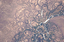
[15] Once a channel begins to follow a sinusoidal path, the amplitude and concavity of the loops increase dramatically.
Wood: "...this process of making meanders seems to be a self-intensifying process...in which greater curvature results in more erosion of the bank, which results in greater curvature..."[16] The cross-current along the floor of the channel is part of the secondary flow and sweeps dense eroded material towards the inside of the bend.
The pressure of the super-elevated column prevails, developing an unbalanced gradient that moves water back across the bottom from the outside to the inside.
[24] A mass of water descending must give up potential energy, which, given the same velocity at the end of the drop as at the beginning, is removed by interaction with the material of the stream bed.
The shortest distance; that is, a straight channel, results in the highest energy per unit of length, disrupting the banks more, creating more sediment and aggrading the stream.
[30] Rincon in English is a nontechnical word in the southwest United States for either a small secluded valley, an alcove or angular recess in a cliff, or a bend in a river.
He argues that the symmetrical valley sides are the direct result of rapid down-cutting of a watercourse into bedrock.
[1][33] In addition, as proposed by Rich,[34] Thornbury argues that incised valleys with a pronounced asymmetry of cross section, which he called ingrown meanders, are the result of the lateral migration and incision of a meander during a period of slower channel downcutting.
Regardless, the formation of both entrenched meanders and ingrown meanders is thought to require that base level falls as a result of either relative change in mean sea level, isostatic or tectonic uplift, the breach of an ice or landslide dam, or regional tilting.
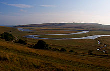
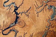
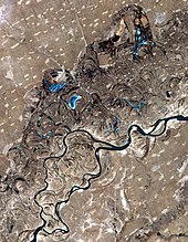
[1] Such lakes form regularly in undisturbed floodplains as a result of the normal process of fluvial meandering.
These delta-like features block either end of the cutoff meander to form a stagnant oxbow lake that is separated from the flow of the fluvial channel and independent of the river.
On the inside bend, this sediment and debris is eventually deposited on the slip-off slope of a point bar.
[1][26][27] Scroll-bars are a result of continuous lateral migration of a meander loop that creates an asymmetrical ridge and swale topography[39] on the inside of the bends.
The topography is generally parallel to the meander, and is related to migrating bar forms and back bar chutes,[40] which carve sediment from the outside of the curve and deposit sediment in the slower flowing water on the inside of the loop, in a process called lateral accretion.
[41] These characteristics are a result of the dynamic river system, where larger grains are transported during high energy flood events and then gradually die down, depositing smaller material with time (Batty 2006).
This is because the tops can be shaped by wind, either adding fine grains or by keeping the area unvegetated, while the darkness in the swales can be attributed to silts and clays washing in during high water periods.
It is produced by the gradual outward migration of the meander as a river cuts downward into bedrock.
Sinuosity indices are calculated from the map or from an aerial photograph measured over a distance called the reach, which should be at least 20 times the average fullbank channel width.
Streams can be placed in categories arranged by it; for example, when the index is between 1 and 1.5 the river is sinuous, but if between 1.5 and 4, then meandering.