El Capitan (Texas)
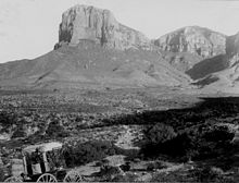
[3] The southern terminus of the Guadalupe Mountains, El Capitan looms over U.S. 62/180, where its imposing height and stark outline have made it one of the iconic images of the Trans-Pecos to generations of travelers.
This reef surrounded much of the Delaware Sea, an inland ocean that covered parts of modern southern New Mexico and Trans-Pecos Texas in the Permian period (about 290 million years ago).
Mineral-rich and cut off from replenishment, the inland sea began to evaporate into layers of alternating gray anhydrite/gypsum, brown calcite, and halite, which formed the Castile Formation.
Exposing the Guadalupe Mountains area of the reef, the impact of this tectonic event can be clearly seen in the difference in height between the towering El Capitan and the adjacent salt flat graben, vertically driven 1,000 feet apart by the uplift.
Once exposed, the natural forces of wind and rain slowly stripped away the softer sediments, further uncovering the ancient reef and revealing the sheer limestone walls of the Guadalupe Mountains.
Dismayed at the prospect of returning by the same route, the party instead struck off east from El Paso towards the Hueco Tanks and Guadalupe Pass, which they hoped to follow to an established crossing of the Pecos River near the modern Texas-New Mexico border long used by Mexicans and Native Americans.
[7] Taking advantage of the water and timber available, the stagecoach line constructed a station at the Pinery, later called Pine Springs, 3 miles southeast of El Capitan.
Quickly becoming an important local resource, generations of Mexicans, and later, Mexican-Americans, braved the hot, dangerous, four-day trail from San Elizario on the Rio Grande to the Hueco Mountains and then east towards El Capitan to fill their wagons with the precious salt.
The southern terminus of the Guadalupe range, El Capitan is guarded by cliffs on three sides, and those faces are rarely climbed due to the unstable condition of the rock and the sheer nature of the peak.