Elizabeth Fort
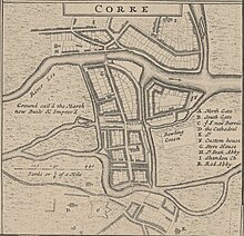
[9][11][12] In John Speed's map of Cork (1610) "Holy Roe"[12] church is marked within the walls of the (then) newly finished fort.
[15] During the Irish War of Independence (1919–1921), Elizabeth Fort was used as a base by the "Black and Tans", but was relinquished by the British following the Anglo-Irish Treaty.
[18] Following the closure of the Garda station buildings, the site came under the management of Cork City Council[18] having previously been in the care of the Office of Public Works.
[19] As an continually active military and police barracks for more than 400 years, Elizabeth Fort had not been open for tourism or heritage development.
However, local interest groups and site stakeholders (namely the Gardaí, Cork City Council and Office of Public Works) had facilitated the development of the ramparts – which were partly opened to access by tourists on a seasonal basis.
[18] In January 2014 the site was fully and formally passed to the control of Cork City Council to facilitate this development under a three-year plan.
[23][24] The walls and certain interior spaces of the fort are open to the public six days a week; Tuesday to Saturday 10:00 to 17:00 and Sunday 12:00 to 17:00, with free admission.