Emery County, Utah
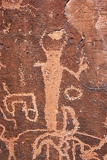
Evidence of these civilizations is extant in numerous pictograph and petroglyph panels, such as those in Temple Mountain Wash, Muddy Creek, Ferron Box, Black Dragon Canyon, and Buckhorn Wash - all sites listed in the National Register of Historic Places.
It then turned south and went through Parowan, Mountain Meadows, Las Vegas Nevada, Barstow California, and to the coast.
The first Americans to come to Castle Valley were fur trappers, including the "lost trappers", James Workman and William Spencer, who had been separated from their trapping party by Comanche Indians and had wandered to the Moab crossing of the Colorado River hoping that they would find Santa Fe.
[5] Following the trappers in the late 1840s and early 1850s, government explorers came to the valley seeking usable overland routes across the continent.
[6] In 1875 livestock growers from Sanpete County brought cattle and sheep into Castle Valley to graze, and several recognized the settlement potential of the region.
With a shortage of sufficient land and water in Sanpete County and a strong desire by LDS Church leaders to acquire unoccupied land in the region before non-Mormons did, young families began moving into Castle Valley in the fall of 1877 to homestead in the future sites of Huntington, Ferron, Castle Dale, and Orangeville.
[8] In late August 1877, Brigham Young, president of the Church of Jesus Christ of Latter-day Saints (LDS Church), issued an order to the Sanpete LDS Stake president seeking "... at least fifty families [to] locate in Castle Valley this fall."
Soon after the issuance of Young's order, several bands of settlers moved out from the Sanpete region and headed for Castle Valley (Emery County).
In the spring of 1878, Elias Cox and Charles Hollingshead set up a sawmill in Huntington Canyon to support the colony.
[10] In the early 1880s, the Denver and Rio Grande Western Railroad contemplated possible routings through the Emery County region.
Early plans to locate the railroad through the heart of Emery County were thwarted when the route over the Wasatch Range was too steep.
Poor drainage and over-irrigation cause the salts to collect on the surface, rendering large land areas unsuitable for agriculture.
The problem first appeared in the 1890s, and in 1903, a Department of Agriculture report stated that over 30% of the developed farmland in Emery County had been abandoned due to degradation.
In addition, the coal industry, which had consisted of small mines to cover local demand, had significantly expanded, with several large-scale operations starting in the county.
The US entry into The Great War created a minor boom in Emery County as agricultural prices rose and manpower shortages caused wages at the mines to rise.
During its tenure in Emery County, the CCC built roads, bridges, and trails, as well as building ranger stations and other projects on public lands.
Following the end of World War II, Emery County veterans returned to find relative economic prosperity.
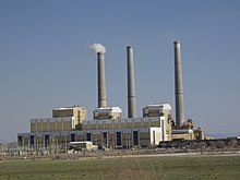
[5] Riding the crest of national economic growth during the 1970s, Emery County's population grew significantly as a result of the construction of large coal-fired power plants in Castle Dale and Huntington by Utah Power & Light Company (PacifiCorp) and the expansion of coal mines to fuel them.
[8] On August 6, 2007, at 2:48 A.M., UtahAmerican Energy's Crandall Canyon Mine, 15 miles (24 kilometers) west north-west of Huntington collapsed, trapping 6 workers inside.
[14] The county terrain is rough flat areas broken by mountain ranges and ridges and carved by water erosion, generally sloping to the south and east.
The western side of the county is the most populated and contains numerous small communities residing in an agricultural valley that roughly parallels the Manti National Forest to the west.
Agricultural areas depend on these reservoirs and waterways for survival, and some farmland communities struggle with excess salinity.
Emery County's maps show the importance of the forest lands to the local communities as there are few significant groundwater aquifers in the area.
Emery County contains three areas: the mountainous Wasatch Plateau to the west; Castle Valley, where the major settlements are located; and the desert of the San Rafael Swell, the San Rafael Reef, Cedar Mountain, and the remote stretches on the east.
The San Rafael River, the lifeblood of the county, originates in the Wasatch Plateau, where the headwaters are stored in several reservoirs for agricultural and industrial use.
Two Ute Indian names: Wasatch, a gap in the mountains; Quitchupah, a place where animals fare poorly.
In 1873, A.D. Ferron, the surveyor sent by Washington to perform cadastral surveys of eastern Utah, named this creek, but before this time, it was the Rafael.
[5] Range Creek rises in Emery County and has recently been shown to have pristine remains of the Fremont culture.
The County still contains extensive natural resources that could be tapped, but the jobs produced from new mining activity may be at a similar level as those replaced by technology.
[26] A proposed nuclear power plant, the Blue Castle Project, is set to begin construction near Green River in 2023.